You are here: Home > Network List > CI - Caltech Regional Seismic Network Stations List
> Station BAR Barrett, Tecate, CA, USA > Earthquake Result Viewer
BAR Barrett, Tecate, CA, USA - Earthquake Result Viewer
| Earthquake location: |
South Of Alaska |
| Earthquake latitude/longitude: |
53.8/-161.1 |
| Earthquake time(UTC): |
2002/05/25 (145) 05:36:31 GMT |
| Earthquake Depth: |
33 km |
| Earthquake Magnitude: |
5.5 MB, 6.1 MS, 6.5 MW, 6.4 MW |
| Earthquake Catalog/Contributor: |
WHDF/NEIC |
|
| Network: |
CI Caltech Regional Seismic Network |
| Station: |
BAR Barrett, Tecate, CA, USA |
| Lat/Lon: |
32.68 N/116.67 W |
| Elevation: |
521 m |
|
| Distance: |
37.8 deg |
| Az: |
105.716 deg |
| Baz: |
317.403 deg |
| Ray Param: |
0.07584388 |
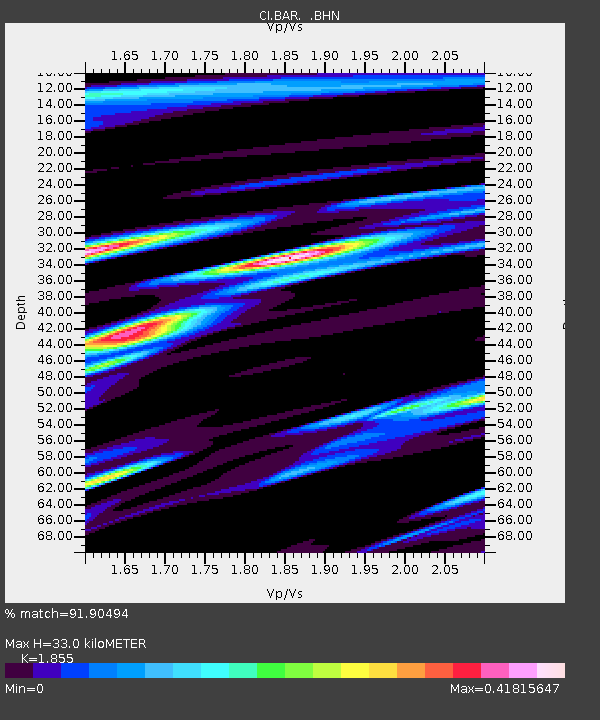
| Estimated Moho Depth: |
33.0 km |
| Estimated Crust Vp/Vs: |
1.86 |
| Assumed Crust Vp: |
6.264 km/s |
| Estimated Crust Vs: |
3.377 km/s |
| Estimated Crust Poisson's Ratio: |
0.30 |
|
| Radial Match: |
91.90494 % |
| Radial Bump: |
335 |
| Transverse Match: |
89.81685 % |
| Transverse Bump: |
362 |
| SOD ConfigId: |
3787 |
| Insert Time: |
2010-02-26 00:07:24.107 +0000 |
| GWidth: |
2.5 |
| Max Bumps: |
400 |
| Tol: |
0.001 |
|
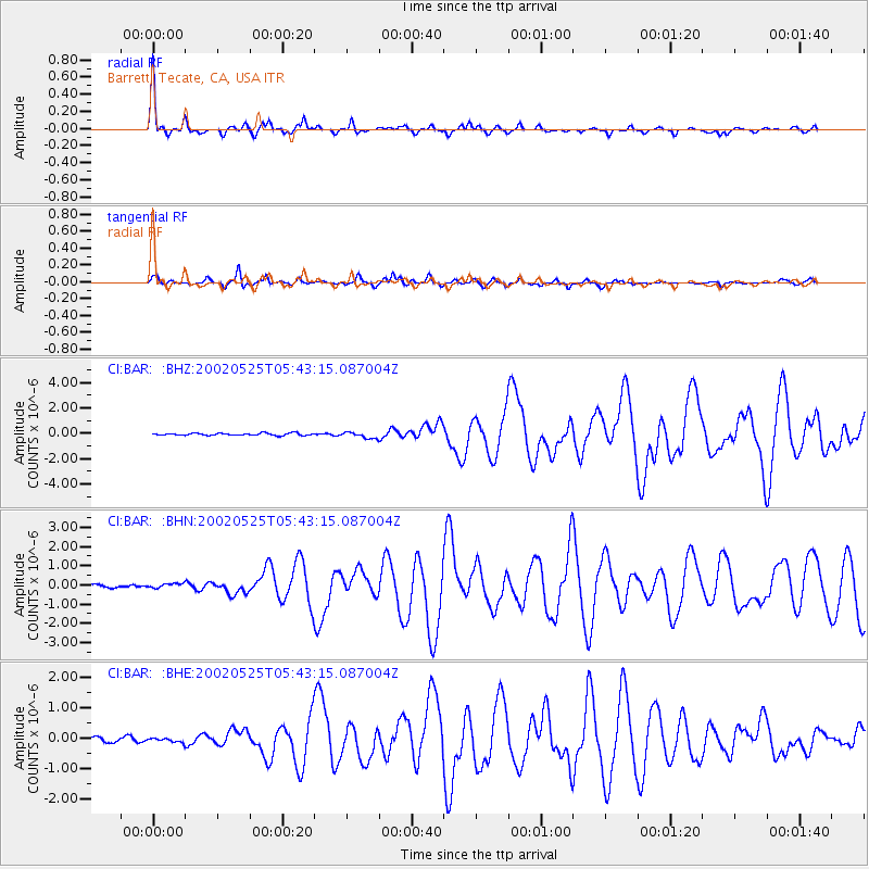
Signal To Noise
| Channel | StoN | STA | LTA |
| CI:BAR: :BHN:20020525T05:43:15.087004Z | 2.016341 | 1.271774E-7 | 6.307336E-8 |
| CI:BAR: :BHE:20020525T05:43:15.087004Z | 0.90822923 | 6.510852E-8 | 7.1687325E-8 |
| CI:BAR: :BHZ:20020525T05:43:15.087004Z | 2.8131187 | 2.4245958E-7 | 8.61889E-8 |
| Arrivals |
| Ps | 4.8 SECOND |
| PpPs | 14 SECOND |
| PsPs/PpSs | 19 SECOND |


