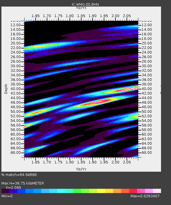
WMQ Urumqi, Xinjiang Province, China - Earthquake Result Viewer

Earthquake location: Irian Jaya Region, Indonesia
Earthquake latitude/longitude: -0.6/133.1
Earthquake time(UTC): 2001/09/11 (254) 14:56:50 GMT
Earthquake Depth: 33 km
Earthquake Magnitude: 5.8 MB, 6.4 MS, 6.6 MW, 6.5 MW
Earthquake Catalog/Contributor: WHDF/NEIC
Network: IC New China Digital Seismograph Network
Station: WMQ Urumqi, Xinjiang Province, China
Lat/Lon: 43.82 N/87.69 E
Elevation: 903 m
Distance: 59.9 deg
Az: 323.426 deg
Baz: 124.597 deg
Ray Param: 0.06180612
Estimated Moho Depth: 39.75 km
Estimated Crust Vp/Vs: 2.07
Assumed Crust Vp: 6.242 km/s
Estimated Crust Vs: 3.023 km/s
Estimated Crust Poisson's Ratio: 0.35
Radial Match: 94.56968 %
Radial Bump: 400
Transverse Match: 89.21599 %
Transverse Bump: 400
SOD ConfigId: 20082
Insert Time: 2010-03-05 00:00:20.587 +0000
GWidth: 2.5
Max Bumps: 400
Tol: 0.001

Signal To Noise

ChannelStoNSTALTA
IC:WMQ:00:BHN:20010911T15:06:23.034014Z2.83159781.725279E-76.092952E-8
IC:WMQ:00:BHE:20010911T15:06:23.036028Z4.97958952.258026E-74.5345622E-8
IC:WMQ:00:BHZ:20010911T15:06:23.034014Z6.1477916.030976E-79.809989E-8
Arrivals
Ps7.0 SECOND
PpPs19 SECOND
PsPs/PpSs26 SECOND