You are here: Home > Network List > IC - New China Digital Seismograph Network Stations List
> Station WMQ Urumqi, Xinjiang Province, China > Earthquake Result Viewer
WMQ Urumqi, Xinjiang Province, China - Earthquake Result Viewer
| Earthquake location: |
North Indian Ocean |
| Earthquake latitude/longitude: |
0.9/82.5 |
| Earthquake time(UTC): |
2001/09/02 (245) 02:25:54 GMT |
| Earthquake Depth: |
10 km |
| Earthquake Magnitude: |
5.6 MB, 5.8 MS, 6.1 MW, 6.1 MW |
| Earthquake Catalog/Contributor: |
WHDF/NEIC |
|
| Network: |
IC New China Digital Seismograph Network |
| Station: |
WMQ Urumqi, Xinjiang Province, China |
| Lat/Lon: |
43.82 N/87.69 E |
| Elevation: |
903 m |
|
| Distance: |
43.0 deg |
| Az: |
5.514 deg |
| Baz: |
187.628 deg |
| Ray Param: |
0.07283491 |
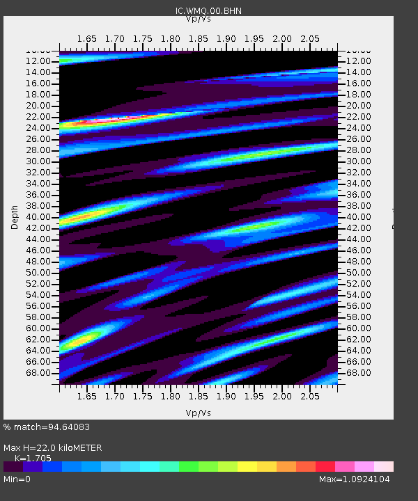
| Estimated Moho Depth: |
22.0 km |
| Estimated Crust Vp/Vs: |
1.71 |
| Assumed Crust Vp: |
6.242 km/s |
| Estimated Crust Vs: |
3.661 km/s |
| Estimated Crust Poisson's Ratio: |
0.24 |
|
| Radial Match: |
94.64083 % |
| Radial Bump: |
385 |
| Transverse Match: |
83.91747 % |
| Transverse Bump: |
400 |
| SOD ConfigId: |
20082 |
| Insert Time: |
2010-03-05 00:00:25.151 +0000 |
| GWidth: |
2.5 |
| Max Bumps: |
400 |
| Tol: |
0.001 |
|
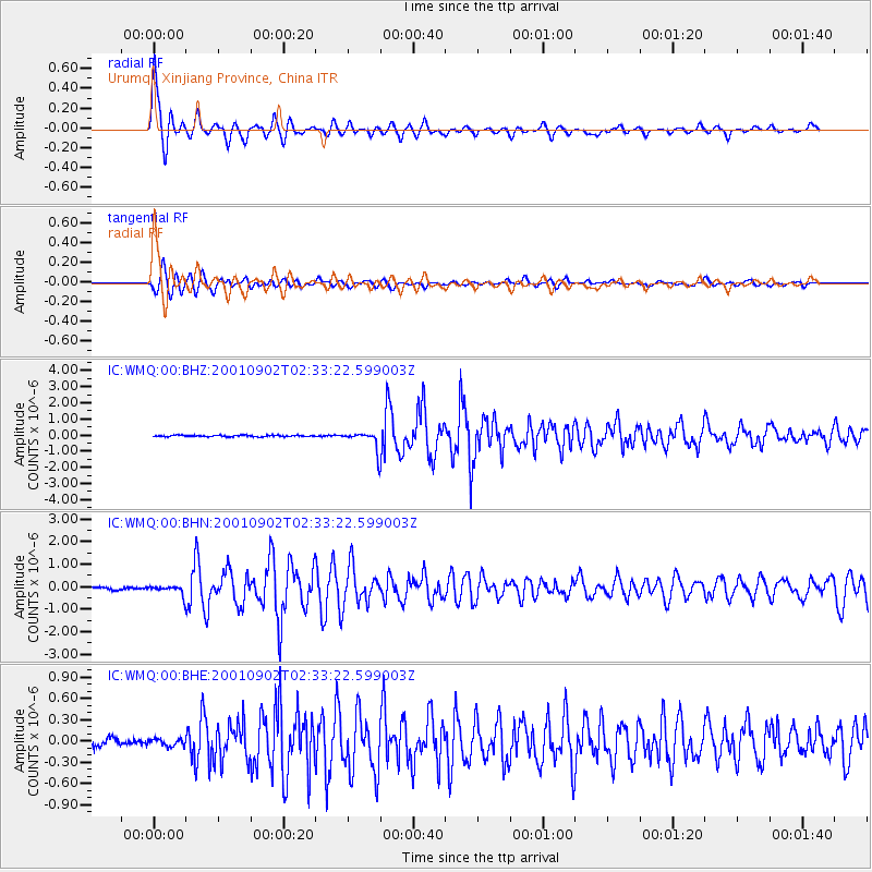
Signal To Noise
| Channel | StoN | STA | LTA |
| IC:WMQ:00:BHN:20010902T02:33:22.599003Z | 3.8543477 | 2.0185169E-7 | 5.2369874E-8 |
| IC:WMQ:00:BHE:20010902T02:33:22.599003Z | 0.96988493 | 5.1397734E-8 | 5.299364E-8 |
| IC:WMQ:00:BHZ:20010902T02:33:22.599003Z | 13.373759 | 5.884961E-7 | 4.400379E-8 |
| Arrivals |
| Ps | 2.7 SECOND |
| PpPs | 8.9 SECOND |
| PsPs/PpSs | 12 SECOND |


