You are here: Home > Network List > TJ - Tajikistan National Seismic Network Stations List
> Station GEZN Gezan, Tajikistan > Earthquake Result Viewer
GEZN Gezan, Tajikistan - Earthquake Result Viewer
| Earthquake location: |
Sumba Region, Indonesia |
| Earthquake latitude/longitude: |
-9.6/119.4 |
| Earthquake time(UTC): |
2016/02/12 (043) 10:02:24 GMT |
| Earthquake Depth: |
30 km |
| Earthquake Magnitude: |
6.5 MWP |
| Earthquake Catalog/Contributor: |
NEIC PDE/NEIC COMCAT |
|
| Network: |
TJ Tajikistan National Seismic Network |
| Station: |
GEZN Gezan, Tajikistan |
| Lat/Lon: |
39.28 N/67.72 E |
| Elevation: |
1485 m |
|
| Distance: |
68.3 deg |
| Az: |
319.042 deg |
| Baz: |
123.596 deg |
| Ray Param: |
0.056364603 |
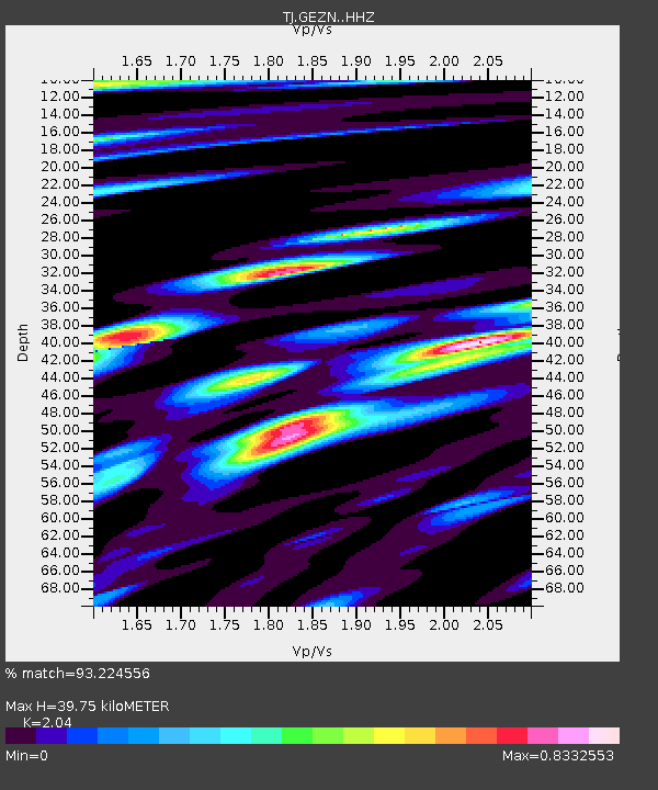
| Estimated Moho Depth: |
39.75 km |
| Estimated Crust Vp/Vs: |
2.04 |
| Assumed Crust Vp: |
6.444 km/s |
| Estimated Crust Vs: |
3.159 km/s |
| Estimated Crust Poisson's Ratio: |
0.34 |
|
| Radial Match: |
93.224556 % |
| Radial Bump: |
400 |
| Transverse Match: |
86.20006 % |
| Transverse Bump: |
400 |
| SOD ConfigId: |
7422571 |
| Insert Time: |
2019-04-21 22:11:44.686 +0000 |
| GWidth: |
2.5 |
| Max Bumps: |
400 |
| Tol: |
0.001 |
|
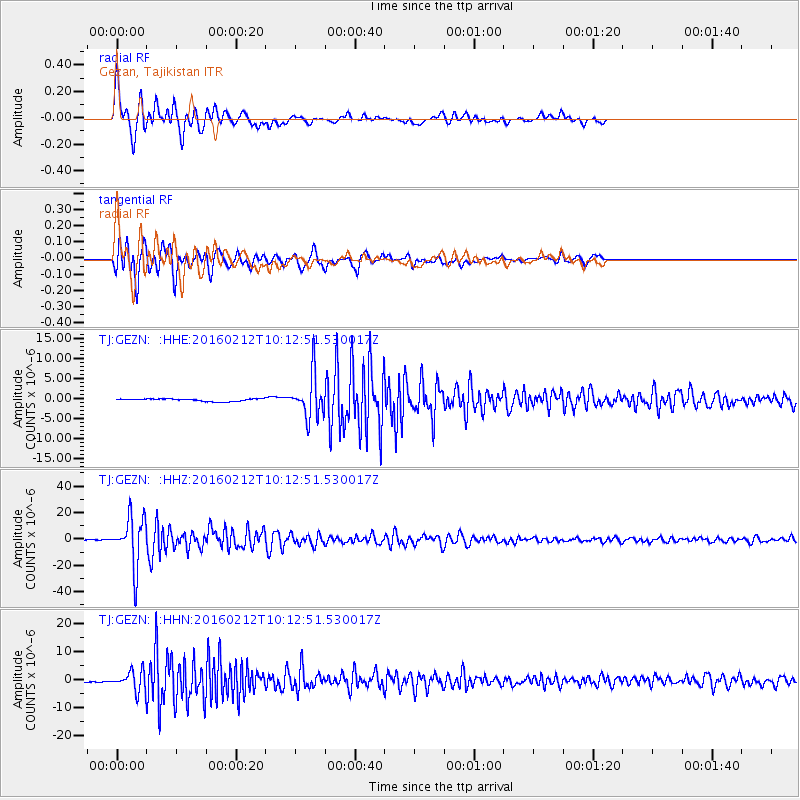
Signal To Noise
| Channel | StoN | STA | LTA |
| TJ:GEZN: :HHZ:20160212T10:12:51.530017Z | 100.16809 | 1.8507046E-5 | 1.8475988E-7 |
| TJ:GEZN: :HHN:20160212T10:12:51.530017Z | 11.446152 | 3.5155754E-6 | 3.0714037E-7 |
| TJ:GEZN: :HHE:20160212T10:12:51.530017Z | 17.140873 | 5.429309E-6 | 3.1674637E-7 |
| Arrivals |
| Ps | 6.6 SECOND |
| PpPs | 18 SECOND |
| PsPs/PpSs | 25 SECOND |


