You are here: Home > Network List > TJ - Tajikistan National Seismic Network Stations List
> Station GARM Garm, Tajikistan > Earthquake Result Viewer
GARM Garm, Tajikistan - Earthquake Result Viewer
| Earthquake location: |
Sumba Region, Indonesia |
| Earthquake latitude/longitude: |
-9.6/119.4 |
| Earthquake time(UTC): |
2016/02/12 (043) 10:02:24 GMT |
| Earthquake Depth: |
30 km |
| Earthquake Magnitude: |
6.5 MWP |
| Earthquake Catalog/Contributor: |
NEIC PDE/NEIC COMCAT |
|
| Network: |
TJ Tajikistan National Seismic Network |
| Station: |
GARM Garm, Tajikistan |
| Lat/Lon: |
39.00 N/70.32 E |
| Elevation: |
1305 m |
|
| Distance: |
66.5 deg |
| Az: |
320.034 deg |
| Baz: |
125.613 deg |
| Ray Param: |
0.057561412 |
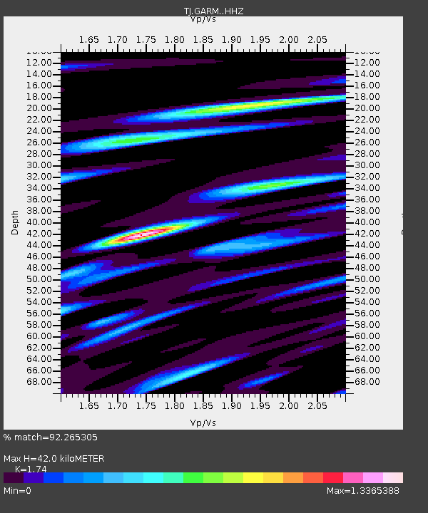
| Estimated Moho Depth: |
42.0 km |
| Estimated Crust Vp/Vs: |
1.74 |
| Assumed Crust Vp: |
6.306 km/s |
| Estimated Crust Vs: |
3.624 km/s |
| Estimated Crust Poisson's Ratio: |
0.25 |
|
| Radial Match: |
92.265305 % |
| Radial Bump: |
400 |
| Transverse Match: |
81.27637 % |
| Transverse Bump: |
400 |
| SOD ConfigId: |
7422571 |
| Insert Time: |
2019-04-21 22:11:45.927 +0000 |
| GWidth: |
2.5 |
| Max Bumps: |
400 |
| Tol: |
0.001 |
|

Signal To Noise
| Channel | StoN | STA | LTA |
| TJ:GARM: :HHZ:20160212T10:12:40.009998Z | 100.2453 | 1.5415424E-5 | 1.5377702E-7 |
| TJ:GARM: :HHN:20160212T10:12:40.009998Z | 29.872875 | 3.850882E-6 | 1.28909E-7 |
| TJ:GARM: :HHE:20160212T10:12:40.009998Z | 31.633064 | 4.5523825E-6 | 1.4391216E-7 |
| Arrivals |
| Ps | 5.1 SECOND |
| PpPs | 18 SECOND |
| PsPs/PpSs | 23 SECOND |


