You are here: Home > Network List > TJ - Tajikistan National Seismic Network Stations List
> Station MANEM Manem, Tajikistan > Earthquake Result Viewer
MANEM Manem, Tajikistan - Earthquake Result Viewer
| Earthquake location: |
Sumba Region, Indonesia |
| Earthquake latitude/longitude: |
-9.6/119.4 |
| Earthquake time(UTC): |
2016/02/12 (043) 10:02:24 GMT |
| Earthquake Depth: |
30 km |
| Earthquake Magnitude: |
6.5 MWP |
| Earthquake Catalog/Contributor: |
NEIC PDE/NEIC COMCAT |
|
| Network: |
TJ Tajikistan National Seismic Network |
| Station: |
MANEM Manem, Tajikistan |
| Lat/Lon: |
37.53 N/71.66 E |
| Elevation: |
2312 m |
|
| Distance: |
64.7 deg |
| Az: |
319.409 deg |
| Baz: |
126.184 deg |
| Ray Param: |
0.058686655 |
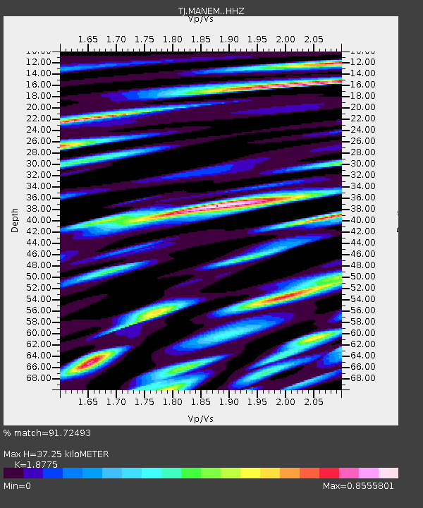
| Estimated Moho Depth: |
37.25 km |
| Estimated Crust Vp/Vs: |
1.88 |
| Assumed Crust Vp: |
6.306 km/s |
| Estimated Crust Vs: |
3.359 km/s |
| Estimated Crust Poisson's Ratio: |
0.30 |
|
| Radial Match: |
91.72493 % |
| Radial Bump: |
400 |
| Transverse Match: |
94.99816 % |
| Transverse Bump: |
400 |
| SOD ConfigId: |
7422571 |
| Insert Time: |
2019-04-21 22:11:46.186 +0000 |
| GWidth: |
2.5 |
| Max Bumps: |
400 |
| Tol: |
0.001 |
|

Signal To Noise
| Channel | StoN | STA | LTA |
| TJ:MANEM: :HHZ:20160212T10:12:28.950Z | 179.20229 | 2.1461934E-5 | 1.1976373E-7 |
| TJ:MANEM: :HHN:20160212T10:12:28.950Z | 62.84064 | 6.1320766E-6 | 9.758138E-8 |
| TJ:MANEM: :HHE:20160212T10:12:28.950Z | 37.262104 | 4.942075E-6 | 1.3263005E-7 |
| Arrivals |
| Ps | 5.4 SECOND |
| PpPs | 16 SECOND |
| PsPs/PpSs | 22 SECOND |


