You are here: Home > Network List > IC - New China Digital Seismograph Network Stations List
> Station WMQ Urumqi, Xinjiang Province, China > Earthquake Result Viewer
WMQ Urumqi, Xinjiang Province, China - Earthquake Result Viewer
| Earthquake location: |
Bismarck Sea |
| Earthquake latitude/longitude: |
-3.4/146.3 |
| Earthquake time(UTC): |
2001/08/23 (235) 21:45:03 GMT |
| Earthquake Depth: |
10 km |
| Earthquake Magnitude: |
5.8 MB, 6.2 MS, 6.2 MW, 6.0 MW |
| Earthquake Catalog/Contributor: |
WHDF/NEIC |
|
| Network: |
IC New China Digital Seismograph Network |
| Station: |
WMQ Urumqi, Xinjiang Province, China |
| Lat/Lon: |
43.82 N/87.69 E |
| Elevation: |
903 m |
|
| Distance: |
70.4 deg |
| Az: |
319.0 deg |
| Baz: |
115.199 deg |
| Ray Param: |
0.05502941 |
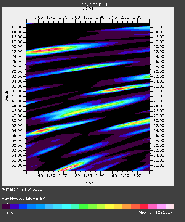
| Estimated Moho Depth: |
69.0 km |
| Estimated Crust Vp/Vs: |
1.77 |
| Assumed Crust Vp: |
6.242 km/s |
| Estimated Crust Vs: |
3.532 km/s |
| Estimated Crust Poisson's Ratio: |
0.26 |
|
| Radial Match: |
94.696556 % |
| Radial Bump: |
400 |
| Transverse Match: |
88.51584 % |
| Transverse Bump: |
400 |
| SOD ConfigId: |
20082 |
| Insert Time: |
2010-03-05 00:00:28.209 +0000 |
| GWidth: |
2.5 |
| Max Bumps: |
400 |
| Tol: |
0.001 |
|

Signal To Noise
| Channel | StoN | STA | LTA |
| IC:WMQ:00:BHN:20010823T21:55:45.883022Z | 1.5171416 | 7.617178E-8 | 5.0207433E-8 |
| IC:WMQ:00:BHE:20010823T21:55:45.883022Z | 1.8547734 | 9.9808E-8 | 5.3811423E-8 |
| IC:WMQ:00:BHZ:20010823T21:55:45.883022Z | 4.171501 | 2.5897333E-7 | 6.208157E-8 |
| Arrivals |
| Ps | 8.8 SECOND |
| PpPs | 30 SECOND |
| PsPs/PpSs | 38 SECOND |


