You are here: Home > Network List > XL12 - Hangay Dome, Mongolia Stations List
> Station AT14 AT14 > Earthquake Result Viewer
AT14 AT14 - Earthquake Result Viewer
| Earthquake location: |
Sumba Region, Indonesia |
| Earthquake latitude/longitude: |
-9.6/119.4 |
| Earthquake time(UTC): |
2016/02/12 (043) 10:02:24 GMT |
| Earthquake Depth: |
30 km |
| Earthquake Magnitude: |
6.5 MWP |
| Earthquake Catalog/Contributor: |
NEIC PDE/NEIC COMCAT |
|
| Network: |
XL Hangay Dome, Mongolia |
| Station: |
AT14 AT14 |
| Lat/Lon: |
45.36 N/96.64 E |
| Elevation: |
2289 m |
|
| Distance: |
58.4 deg |
| Az: |
341.319 deg |
| Baz: |
153.384 deg |
| Ray Param: |
0.06281047 |
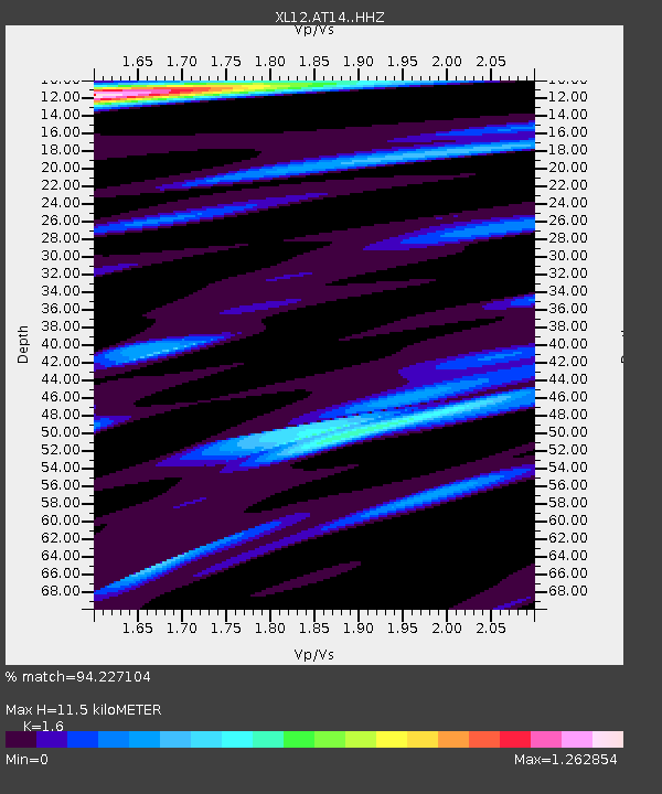
| Estimated Moho Depth: |
11.5 km |
| Estimated Crust Vp/Vs: |
1.60 |
| Assumed Crust Vp: |
6.353 km/s |
| Estimated Crust Vs: |
3.971 km/s |
| Estimated Crust Poisson's Ratio: |
0.18 |
|
| Radial Match: |
94.227104 % |
| Radial Bump: |
400 |
| Transverse Match: |
82.256134 % |
| Transverse Bump: |
400 |
| SOD ConfigId: |
7422571 |
| Insert Time: |
2019-04-21 22:12:04.705 +0000 |
| GWidth: |
2.5 |
| Max Bumps: |
400 |
| Tol: |
0.001 |
|

Signal To Noise
| Channel | StoN | STA | LTA |
| XL:AT14: :HHZ:20160212T10:11:46.468982Z | 33.954357 | 2.2053948E-6 | 6.495175E-8 |
| XL:AT14: :HHN:20160212T10:11:46.468982Z | 17.049086 | 8.562816E-7 | 5.022449E-8 |
| XL:AT14: :HHE:20160212T10:11:46.468982Z | 7.7458124 | 5.3598194E-7 | 6.919635E-8 |
| Arrivals |
| Ps | 1.1 SECOND |
| PpPs | 4.5 SECOND |
| PsPs/PpSs | 5.6 SECOND |


