You are here: Home > Network List > YT07 - POLENET Stations List
> Station MA10 Polenet mini-array MA10 > Earthquake Result Viewer
MA10 Polenet mini-array MA10 - Earthquake Result Viewer
| Earthquake location: |
Sumba Region, Indonesia |
| Earthquake latitude/longitude: |
-9.6/119.4 |
| Earthquake time(UTC): |
2016/02/12 (043) 10:02:24 GMT |
| Earthquake Depth: |
30 km |
| Earthquake Magnitude: |
6.5 MWP |
| Earthquake Catalog/Contributor: |
NEIC PDE/NEIC COMCAT |
|
| Network: |
YT POLENET |
| Station: |
MA10 Polenet mini-array MA10 |
| Lat/Lon: |
78.60 S/109.00 W |
| Elevation: |
1658 m |
|
| Distance: |
88.2 deg |
| Az: |
171.44 deg |
| Baz: |
227.552 deg |
| Ray Param: |
0.04274982 |
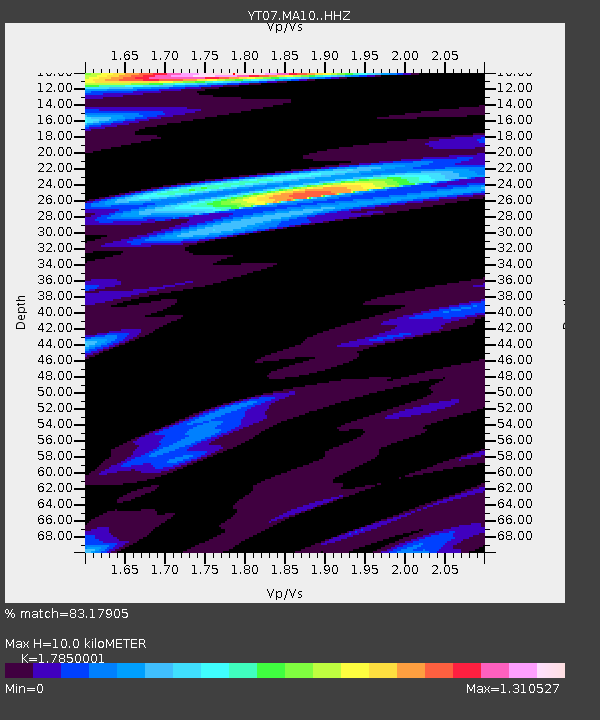
| Estimated Moho Depth: |
10.0 km |
| Estimated Crust Vp/Vs: |
1.79 |
| Assumed Crust Vp: |
5.872 km/s |
| Estimated Crust Vs: |
3.29 km/s |
| Estimated Crust Poisson's Ratio: |
0.27 |
|
| Radial Match: |
83.17905 % |
| Radial Bump: |
329 |
| Transverse Match: |
65.300835 % |
| Transverse Bump: |
361 |
| SOD ConfigId: |
7422571 |
| Insert Time: |
2019-04-21 22:12:52.352 +0000 |
| GWidth: |
2.5 |
| Max Bumps: |
400 |
| Tol: |
0.001 |
|

Signal To Noise
| Channel | StoN | STA | LTA |
| YT:MA10: :HHZ:20160212T10:14:40.72002Z | 1.6185644 | 3.9528035E-7 | 2.4421664E-7 |
| YT:MA10: :HHN:20160212T10:14:40.72002Z | 1.3097001 | 3.92916E-7 | 3.0000456E-7 |
| YT:MA10: :HHE:20160212T10:14:40.72002Z | 1.9165477 | 3.0541906E-7 | 1.5935896E-7 |
| Arrivals |
| Ps | 1.4 SECOND |
| PpPs | 4.7 SECOND |
| PsPs/PpSs | 6.0 SECOND |


