You are here: Home > Network List > WY - Yellowstone Wyoming Seismic Network Stations List
> Station YHH Holmes Hill, YNP, WY, USA > Earthquake Result Viewer
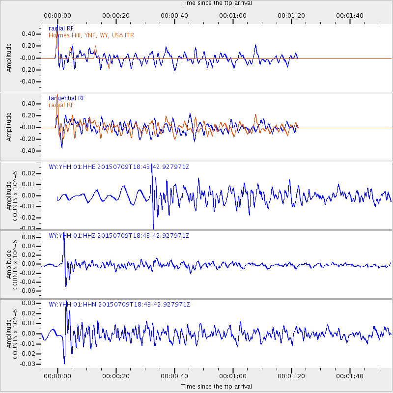
YHH Holmes Hill, YNP, WY, USA - Earthquake Result Viewer
*The percent match for this event was below the threshold and hence no stack was calculated.
| Earthquake location: |
Near East Coast Of Honshu, Japan |
| Earthquake latitude/longitude: |
40.4/141.5 |
| Earthquake time(UTC): |
2015/07/09 (190) 18:32:51 GMT |
| Earthquake Depth: |
79 km |
| Earthquake Magnitude: |
5.6 MWB, 5.5 MWW, 5.6 MWR, 5.6 MWC |
| Earthquake Catalog/Contributor: |
NEIC PDE/NEIC COMCAT |
|
| Network: |
WY Yellowstone Wyoming Seismic Network |
| Station: |
YHH Holmes Hill, YNP, WY, USA |
| Lat/Lon: |
44.79 N/110.85 W |
| Elevation: |
2717 m |
|
| Distance: |
73.3 deg |
| Az: |
45.109 deg |
| Baz: |
310.519 deg |
| Ray Param: |
$rayparam |
*The percent match for this event was below the threshold and hence was not used in the summary stack. |
|
| Radial Match: |
77.23417 % |
| Radial Bump: |
356 |
| Transverse Match: |
58.337215 % |
| Transverse Bump: |
400 |
| SOD ConfigId: |
1080791 |
| Insert Time: |
2015-07-23 20:49:58.389 +0000 |
| GWidth: |
2.5 |
| Max Bumps: |
400 |
| Tol: |
0.001 |
|
Signal To Noise
| Channel | StoN | STA | LTA |
| WY:YHH:01:HHZ:20150709T18:43:42.927971Z | 13.429157 | 2.4349402E-8 | 1.8131743E-9 |
| WY:YHH:01:HHN:20150709T18:43:42.927971Z | 4.5233526 | 1.2961323E-8 | 2.8654241E-9 |
| WY:YHH:01:HHE:20150709T18:43:42.927971Z | 3.7199416 | 1.2072046E-8 | 3.2452245E-9 |
| Arrivals |
| Ps | |
| PpPs | |
| PsPs/PpSs | |


