You are here: Home > Network List > IC - New China Digital Seismograph Network Stations List
> Station WMQ Urumqi, Xinjiang Province, China > Earthquake Result Viewer
WMQ Urumqi, Xinjiang Province, China - Earthquake Result Viewer
| Earthquake location: |
Solomon Islands |
| Earthquake latitude/longitude: |
-7.3/156.0 |
| Earthquake time(UTC): |
2001/04/19 (109) 20:58:26 GMT |
| Earthquake Depth: |
20 km |
| Earthquake Magnitude: |
5.7 MB, 6.1 MS, 6.2 MW, 5.9 ME |
| Earthquake Catalog/Contributor: |
WHDF/NEIC |
|
| Network: |
IC New China Digital Seismograph Network |
| Station: |
WMQ Urumqi, Xinjiang Province, China |
| Lat/Lon: |
43.82 N/87.69 E |
| Elevation: |
903 m |
|
| Distance: |
79.7 deg |
| Az: |
316.891 deg |
| Baz: |
110.517 deg |
| Ray Param: |
0.048757702 |
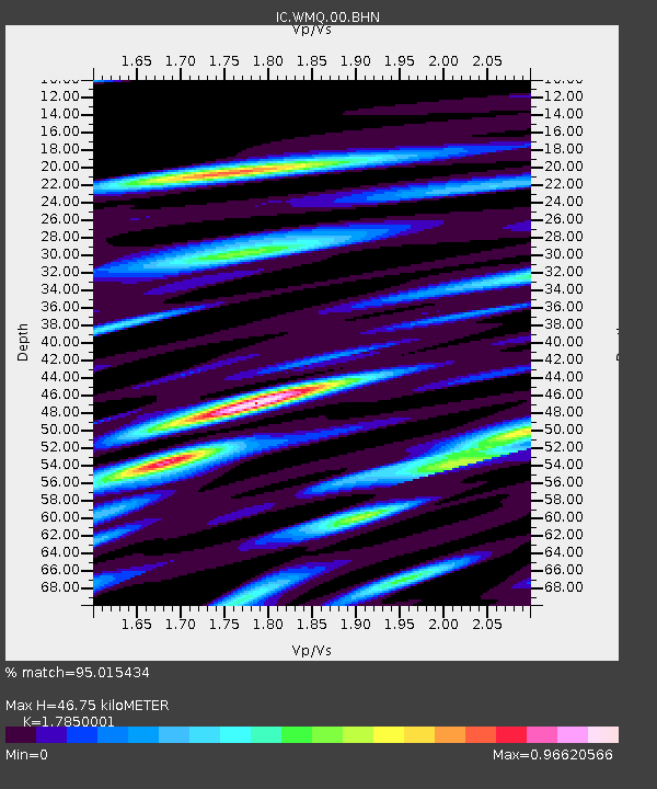
| Estimated Moho Depth: |
46.75 km |
| Estimated Crust Vp/Vs: |
1.79 |
| Assumed Crust Vp: |
6.242 km/s |
| Estimated Crust Vs: |
3.497 km/s |
| Estimated Crust Poisson's Ratio: |
0.27 |
|
| Radial Match: |
95.015434 % |
| Radial Bump: |
400 |
| Transverse Match: |
91.948235 % |
| Transverse Bump: |
400 |
| SOD ConfigId: |
4714 |
| Insert Time: |
2010-03-05 00:01:12.712 +0000 |
| GWidth: |
2.5 |
| Max Bumps: |
400 |
| Tol: |
0.001 |
|
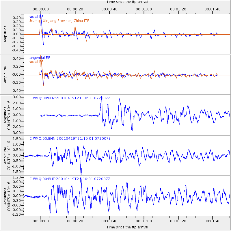
Signal To Noise
| Channel | StoN | STA | LTA |
| IC:WMQ:00:BHN:20010419T21:10:01.072007Z | 0.73225594 | 3.9502066E-8 | 5.394571E-8 |
| IC:WMQ:00:BHE:20010419T21:10:01.072007Z | 2.211634 | 7.213028E-8 | 3.2614018E-8 |
| IC:WMQ:00:BHZ:20010419T21:10:01.072007Z | 4.1984963 | 2.932366E-7 | 6.9843246E-8 |
| Arrivals |
| Ps | 6.0 SECOND |
| PpPs | 20 SECOND |
| PsPs/PpSs | 26 SECOND |


