You are here: Home > Network List > IC - New China Digital Seismograph Network Stations List
> Station WMQ Urumqi, Xinjiang Province, China > Earthquake Result Viewer
WMQ Urumqi, Xinjiang Province, China - Earthquake Result Viewer
| Earthquake location: |
Solomon Islands |
| Earthquake latitude/longitude: |
-7.4/155.9 |
| Earthquake time(UTC): |
2001/04/19 (109) 21:43:42 GMT |
| Earthquake Depth: |
17 km |
| Earthquake Magnitude: |
6.0 MB, 6.6 MS, 6.7 MW, 6.2 ME |
| Earthquake Catalog/Contributor: |
WHDF/NEIC |
|
| Network: |
IC New China Digital Seismograph Network |
| Station: |
WMQ Urumqi, Xinjiang Province, China |
| Lat/Lon: |
43.82 N/87.69 E |
| Elevation: |
903 m |
|
| Distance: |
79.7 deg |
| Az: |
316.93 deg |
| Baz: |
110.663 deg |
| Ray Param: |
0.048757903 |
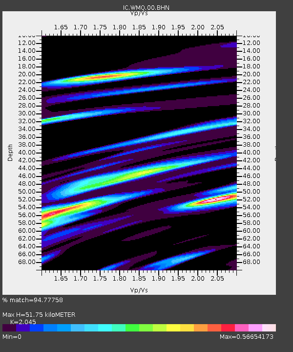
| Estimated Moho Depth: |
51.75 km |
| Estimated Crust Vp/Vs: |
2.05 |
| Assumed Crust Vp: |
6.242 km/s |
| Estimated Crust Vs: |
3.052 km/s |
| Estimated Crust Poisson's Ratio: |
0.34 |
|
| Radial Match: |
94.77758 % |
| Radial Bump: |
400 |
| Transverse Match: |
85.29142 % |
| Transverse Bump: |
400 |
| SOD ConfigId: |
4714 |
| Insert Time: |
2010-03-05 00:01:14.964 +0000 |
| GWidth: |
2.5 |
| Max Bumps: |
400 |
| Tol: |
0.001 |
|
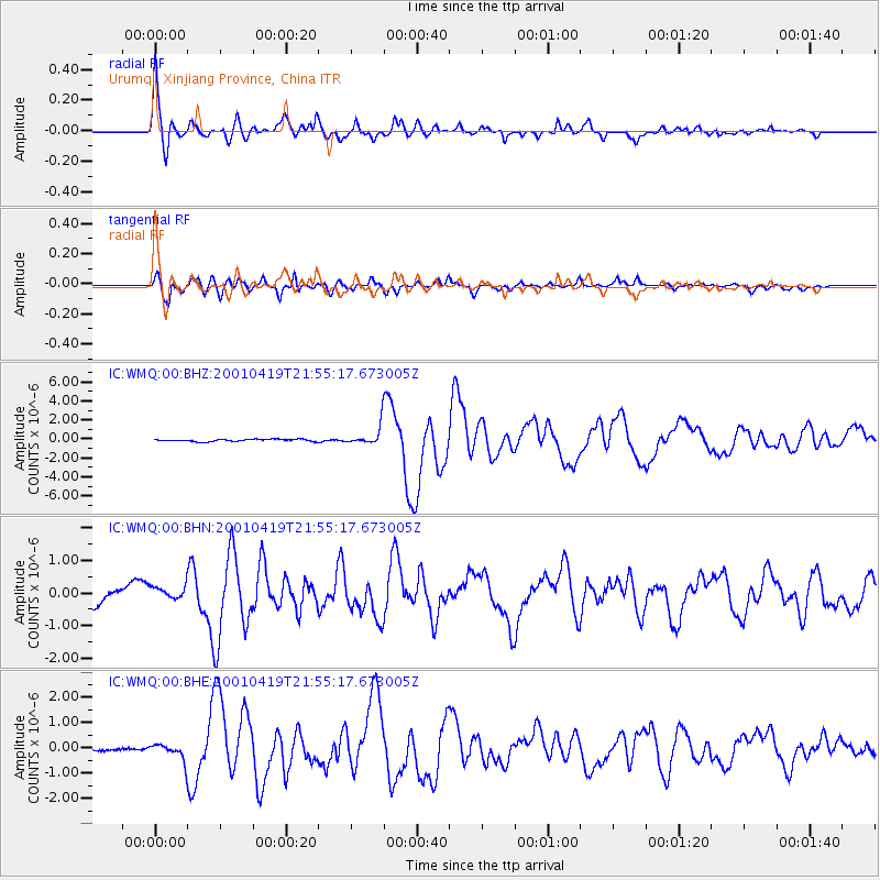
Signal To Noise
| Channel | StoN | STA | LTA |
| IC:WMQ:00:BHN:20010419T21:55:17.673005Z | 1.099612 | 1.9927724E-7 | 1.8122505E-7 |
| IC:WMQ:00:BHE:20010419T21:55:17.673005Z | 4.3905187 | 3.1677513E-7 | 7.214982E-8 |
| IC:WMQ:00:BHZ:20010419T21:55:17.673005Z | 8.767025 | 1.0160643E-6 | 1.15896135E-7 |
| Arrivals |
| Ps | 8.9 SECOND |
| PpPs | 25 SECOND |
| PsPs/PpSs | 34 SECOND |


