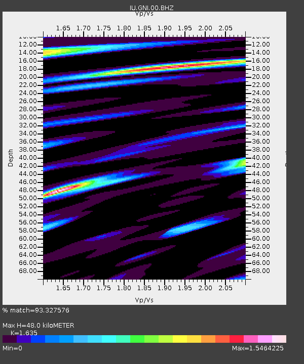
GNI Garni, Armenia - Earthquake Result Viewer
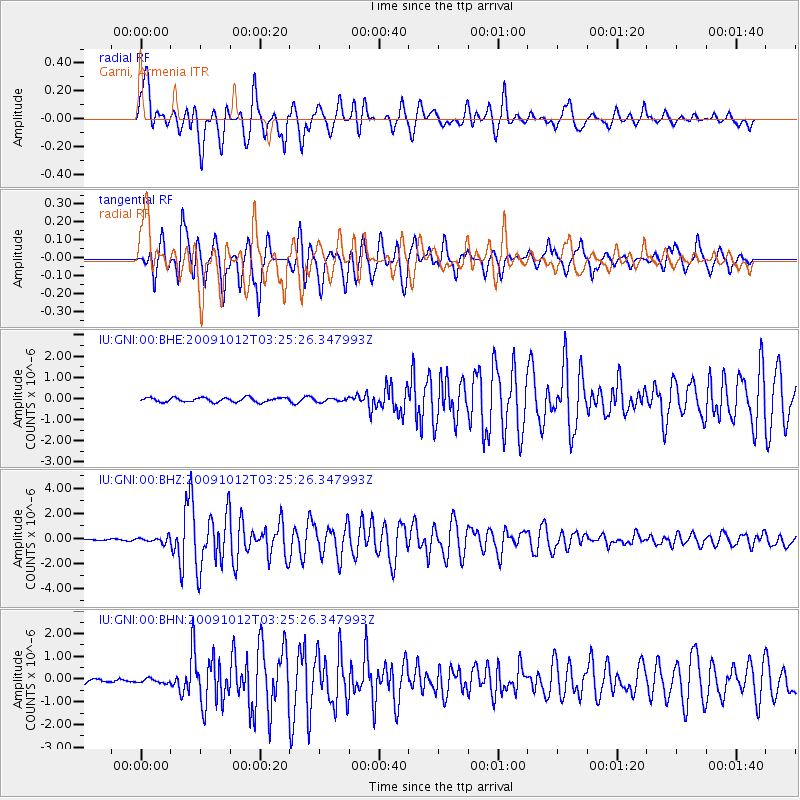
Earthquake location: Mauritius - Reunion Region
Earthquake latitude/longitude: -17.1/66.7
Earthquake time(UTC): 2009/10/12 (285) 03:15:47 GMT
Earthquake Depth: 10 km
Earthquake Magnitude: 6.2 MB, 6.0 MS, 6.2 MW, 6.1 MW
Earthquake Catalog/Contributor: WHDF/NEIC
Network: IU Global Seismograph Network (GSN - IRIS/USGS)
Station: GNI Garni, Armenia
Lat/Lon: 40.15 N/44.74 E
Elevation: 1609 m
Distance: 60.5 deg
Az: 340.785 deg
Baz: 155.756 deg
Ray Param: 0.06148402
Estimated Moho Depth: 48.0 km
Estimated Crust Vp/Vs: 1.63
Assumed Crust Vp: 6.291 km/s
Estimated Crust Vs: 3.848 km/s
Estimated Crust Poisson's Ratio: 0.20
Radial Match: 93.327576 %
Radial Bump: 400
Transverse Match: 92.31088 %
Transverse Bump: 400
SOD ConfigId: 1
Insert Time: 2010-02-19 00:42:33.398 +0000
GWidth: 2.5
Max Bumps: 400
Tol: 0.001

Signal To Noise

ChannelStoNSTALTA
IU:GNI:00:BHZ:20091012T03:25:26.347993Z2.37778382.2203359E-79.3378375E-8
IU:GNI:00:BHN:20091012T03:25:26.347993Z0.965964148.990949E-89.307746E-8
IU:GNI:00:BHE:20091012T03:25:26.347993Z0.81344548.385316E-81.0308394E-7
Arrivals
Ps5.1 SECOND
PpPs19 SECOND
PsPs/PpSs24 SECOND