You are here: Home > Network List > IC - New China Digital Seismograph Network Stations List
> Station KMI Kunming, Yunnan Province, China > Earthquake Result Viewer
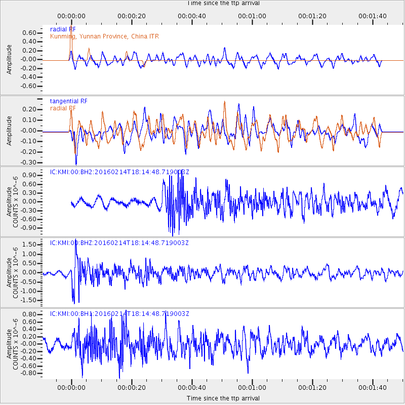
KMI Kunming, Yunnan Province, China - Earthquake Result Viewer
*The percent match for this event was below the threshold and hence no stack was calculated.
| Earthquake location: |
Southeast Of Honshu, Japan |
| Earthquake latitude/longitude: |
30.3/138.9 |
| Earthquake time(UTC): |
2016/02/14 (045) 18:09:26 GMT |
| Earthquake Depth: |
413 km |
| Earthquake Magnitude: |
5.7 MB |
| Earthquake Catalog/Contributor: |
NEIC PDE/NEIC COMCAT |
|
| Network: |
IC New China Digital Seismograph Network |
| Station: |
KMI Kunming, Yunnan Province, China |
| Lat/Lon: |
25.12 N/102.74 E |
| Elevation: |
1975 m |
|
| Distance: |
32.3 deg |
| Az: |
269.733 deg |
| Baz: |
72.565 deg |
| Ray Param: |
$rayparam |
*The percent match for this event was below the threshold and hence was not used in the summary stack. |
|
| Radial Match: |
57.954594 % |
| Radial Bump: |
400 |
| Transverse Match: |
66.00784 % |
| Transverse Bump: |
400 |
| SOD ConfigId: |
7422571 |
| Insert Time: |
2019-04-21 22:18:31.425 +0000 |
| GWidth: |
2.5 |
| Max Bumps: |
400 |
| Tol: |
0.001 |
|
Signal To Noise
| Channel | StoN | STA | LTA |
| IC:KMI:00:BHZ:20160214T18:14:48.719003Z | 7.5743556 | 8.0805347E-7 | 1.066828E-7 |
| IC:KMI:00:BH1:20160214T18:14:48.719003Z | 2.310032 | 3.1193957E-7 | 1.3503691E-7 |
| IC:KMI:00:BH2:20160214T18:14:48.719003Z | 5.0885477 | 5.334166E-7 | 1.0482688E-7 |
| Arrivals |
| Ps | |
| PpPs | |
| PsPs/PpSs | |


