You are here: Home > Network List > CI - Caltech Regional Seismic Network Stations List
> Station BAR Barrett, Tecate, CA, USA > Earthquake Result Viewer
BAR Barrett, Tecate, CA, USA - Earthquake Result Viewer
| Earthquake location: |
Unimak Island Region, Alaska |
| Earthquake latitude/longitude: |
53.6/-164.6 |
| Earthquake time(UTC): |
2003/02/19 (050) 03:32:36 GMT |
| Earthquake Depth: |
19 km |
| Earthquake Magnitude: |
5.8 MB, 6.6 MS, 6.6 MW, 6.6 MW |
| Earthquake Catalog/Contributor: |
WHDF/NEIC |
|
| Network: |
CI Caltech Regional Seismic Network |
| Station: |
BAR Barrett, Tecate, CA, USA |
| Lat/Lon: |
32.68 N/116.67 W |
| Elevation: |
521 m |
|
| Distance: |
39.8 deg |
| Az: |
102.049 deg |
| Baz: |
316.337 deg |
| Ray Param: |
0.074729316 |
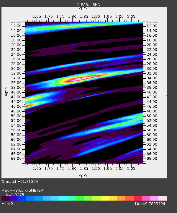
| Estimated Moho Depth: |
34.0 km |
| Estimated Crust Vp/Vs: |
1.84 |
| Assumed Crust Vp: |
6.264 km/s |
| Estimated Crust Vs: |
3.409 km/s |
| Estimated Crust Poisson's Ratio: |
0.29 |
|
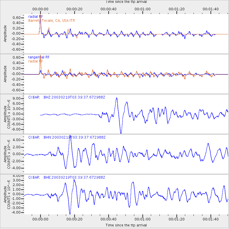
| Radial Match: |
91.71324 % |
| Radial Bump: |
329 |
| Transverse Match: |
81.90301 % |
| Transverse Bump: |
400 |
| SOD ConfigId: |
3770 |
| Insert Time: |
2010-02-26 00:07:38.034 +0000 |
| GWidth: |
2.5 |
| Max Bumps: |
400 |
| Tol: |
0.001 |
|
Signal To Noise
| Channel | StoN | STA | LTA |
| CI:BAR: :BHN:20030219T03:39:37.672988Z | 0.5942555 | 1.280643E-7 | 2.1550377E-7 |
| CI:BAR: :BHE:20030219T03:39:37.672988Z | 0.9573577 | 1.0704513E-7 | 1.11813094E-7 |
| CI:BAR: :BHZ:20030219T03:39:37.672988Z | 1.2423904 | 3.0165688E-7 | 2.4280362E-7 |
| Arrivals |
| Ps | 4.8 SECOND |
| PpPs | 14 SECOND |
| PsPs/PpSs | 19 SECOND |


