You are here: Home > Network List > IC - New China Digital Seismograph Network Stations List
> Station WMQ Urumqi, Xinjiang Province, China > Earthquake Result Viewer
WMQ Urumqi, Xinjiang Province, China - Earthquake Result Viewer
| Earthquake location: |
Sunda Strait, Indonesia |
| Earthquake latitude/longitude: |
-7.0/104.2 |
| Earthquake time(UTC): |
2002/06/27 (178) 05:50:35 GMT |
| Earthquake Depth: |
11 km |
| Earthquake Magnitude: |
6.0 MB, 6.9 MS, 6.6 MW, 6.5 MW |
| Earthquake Catalog/Contributor: |
WHDF/NEIC |
|
| Network: |
IC New China Digital Seismograph Network |
| Station: |
WMQ Urumqi, Xinjiang Province, China |
| Lat/Lon: |
43.82 N/87.69 E |
| Elevation: |
903 m |
|
| Distance: |
52.7 deg |
| Az: |
345.036 deg |
| Baz: |
159.26 deg |
| Ray Param: |
0.066586375 |
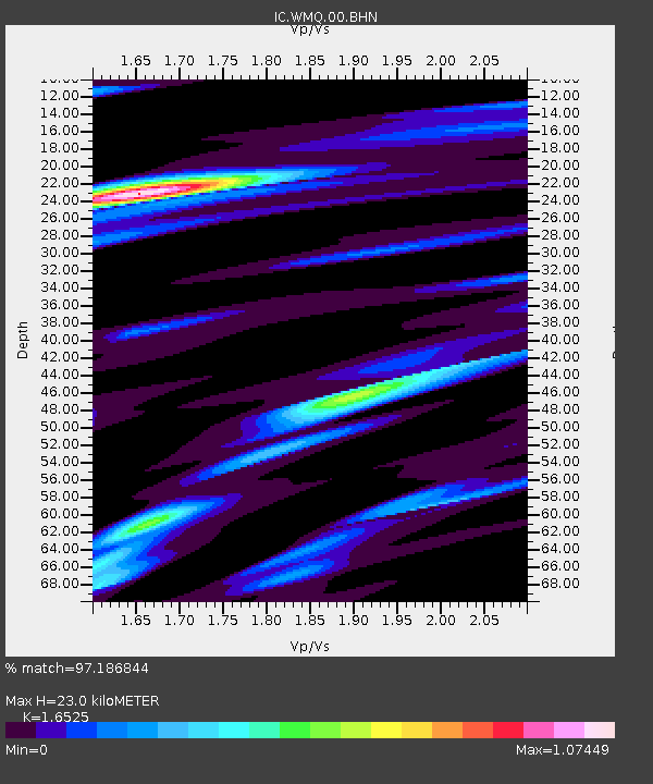
| Estimated Moho Depth: |
23.0 km |
| Estimated Crust Vp/Vs: |
1.65 |
| Assumed Crust Vp: |
6.242 km/s |
| Estimated Crust Vs: |
3.777 km/s |
| Estimated Crust Poisson's Ratio: |
0.21 |
|
| Radial Match: |
97.186844 % |
| Radial Bump: |
400 |
| Transverse Match: |
90.789314 % |
| Transverse Bump: |
400 |
| SOD ConfigId: |
20082 |
| Insert Time: |
2010-03-05 00:02:52.715 +0000 |
| GWidth: |
2.5 |
| Max Bumps: |
400 |
| Tol: |
0.001 |
|

Signal To Noise
| Channel | StoN | STA | LTA |
| IC:WMQ:00:BHN:20020627T05:59:18.573013Z | 11.319543 | 5.256252E-7 | 4.6435193E-8 |
| IC:WMQ:00:BHE:20020627T05:59:18.573013Z | 5.3862 | 2.5539254E-7 | 4.741609E-8 |
| IC:WMQ:00:BHZ:20020627T05:59:18.573013Z | 15.887485 | 1.2927426E-6 | 8.136861E-8 |
| Arrivals |
| Ps | 2.5 SECOND |
| PpPs | 9.2 SECOND |
| PsPs/PpSs | 12 SECOND |


