You are here: Home > Network List > AU - Australian Seismological Centre Stations List
> Station CTA Charters Towers, Queensland > Earthquake Result Viewer
CTA Charters Towers, Queensland - Earthquake Result Viewer
| Earthquake location: |
Tonga Islands |
| Earthquake latitude/longitude: |
-21.0/-175.5 |
| Earthquake time(UTC): |
2016/02/15 (046) 15:02:33 GMT |
| Earthquake Depth: |
10 km |
| Earthquake Magnitude: |
5.7 MB |
| Earthquake Catalog/Contributor: |
NEIC PDE/NEIC COMCAT |
|
| Network: |
AU Australian Seismological Centre |
| Station: |
CTA Charters Towers, Queensland |
| Lat/Lon: |
20.09 S/146.25 E |
| Elevation: |
426 m |
|
| Distance: |
35.8 deg |
| Az: |
264.513 deg |
| Baz: |
98.303 deg |
| Ray Param: |
0.077053316 |
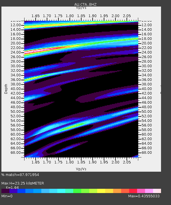
| Estimated Moho Depth: |
23.25 km |
| Estimated Crust Vp/Vs: |
1.64 |
| Assumed Crust Vp: |
6.522 km/s |
| Estimated Crust Vs: |
3.977 km/s |
| Estimated Crust Poisson's Ratio: |
0.20 |
|
| Radial Match: |
87.971954 % |
| Radial Bump: |
264 |
| Transverse Match: |
60.41817 % |
| Transverse Bump: |
400 |
| SOD ConfigId: |
7422571 |
| Insert Time: |
2019-04-21 22:24:54.906 +0000 |
| GWidth: |
2.5 |
| Max Bumps: |
400 |
| Tol: |
0.001 |
|

Signal To Noise
| Channel | StoN | STA | LTA |
| AU:CTA: :BHZ:20160215T15:09:01.449993Z | 3.3401864 | 5.2938583E-7 | 1.5848991E-7 |
| AU:CTA: :BHN:20160215T15:09:01.449993Z | 1.464977 | 2.0736788E-7 | 1.4155026E-7 |
| AU:CTA: :BHE:20160215T15:09:01.449993Z | 1.1596906 | 3.331247E-7 | 2.8725307E-7 |
| Arrivals |
| Ps | 2.5 SECOND |
| PpPs | 8.6 SECOND |
| PsPs/PpSs | 11 SECOND |


