You are here: Home > Network List > CI - Caltech Regional Seismic Network Stations List
> Station SLA SLA, Trona, CA, USA > Earthquake Result Viewer
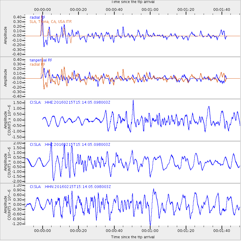
SLA SLA, Trona, CA, USA - Earthquake Result Viewer
*The percent match for this event was below the threshold and hence no stack was calculated.
| Earthquake location: |
Tonga Islands |
| Earthquake latitude/longitude: |
-21.0/-175.5 |
| Earthquake time(UTC): |
2016/02/15 (046) 15:02:33 GMT |
| Earthquake Depth: |
10 km |
| Earthquake Magnitude: |
5.7 MB |
| Earthquake Catalog/Contributor: |
NEIC PDE/NEIC COMCAT |
|
| Network: |
CI Caltech Regional Seismic Network |
| Station: |
SLA SLA, Trona, CA, USA |
| Lat/Lon: |
35.89 N/117.28 W |
| Elevation: |
1174 m |
|
| Distance: |
79.0 deg |
| Az: |
44.7 deg |
| Baz: |
234.034 deg |
| Ray Param: |
$rayparam |
*The percent match for this event was below the threshold and hence was not used in the summary stack. |
|
| Radial Match: |
72.91827 % |
| Radial Bump: |
400 |
| Transverse Match: |
68.68791 % |
| Transverse Bump: |
400 |
| SOD ConfigId: |
7422571 |
| Insert Time: |
2019-04-21 22:26:13.808 +0000 |
| GWidth: |
2.5 |
| Max Bumps: |
400 |
| Tol: |
0.001 |
|
Signal To Noise
| Channel | StoN | STA | LTA |
| CI:SLA: :HHZ:20160215T15:14:05.098003Z | 2.3733125 | 6.424835E-7 | 2.707117E-7 |
| CI:SLA: :HHN:20160215T15:14:05.098003Z | 0.96584177 | 2.1743438E-7 | 2.2512423E-7 |
| CI:SLA: :HHE:20160215T15:14:05.098003Z | 1.0456618 | 2.5468975E-7 | 2.43568E-7 |
| Arrivals |
| Ps | |
| PpPs | |
| PsPs/PpSs | |


