You are here: Home > Network List > UW - Pacific Northwest Regional Seismic Network Stations List
> Station UMAT Pilot Rock, OR, USA > Earthquake Result Viewer
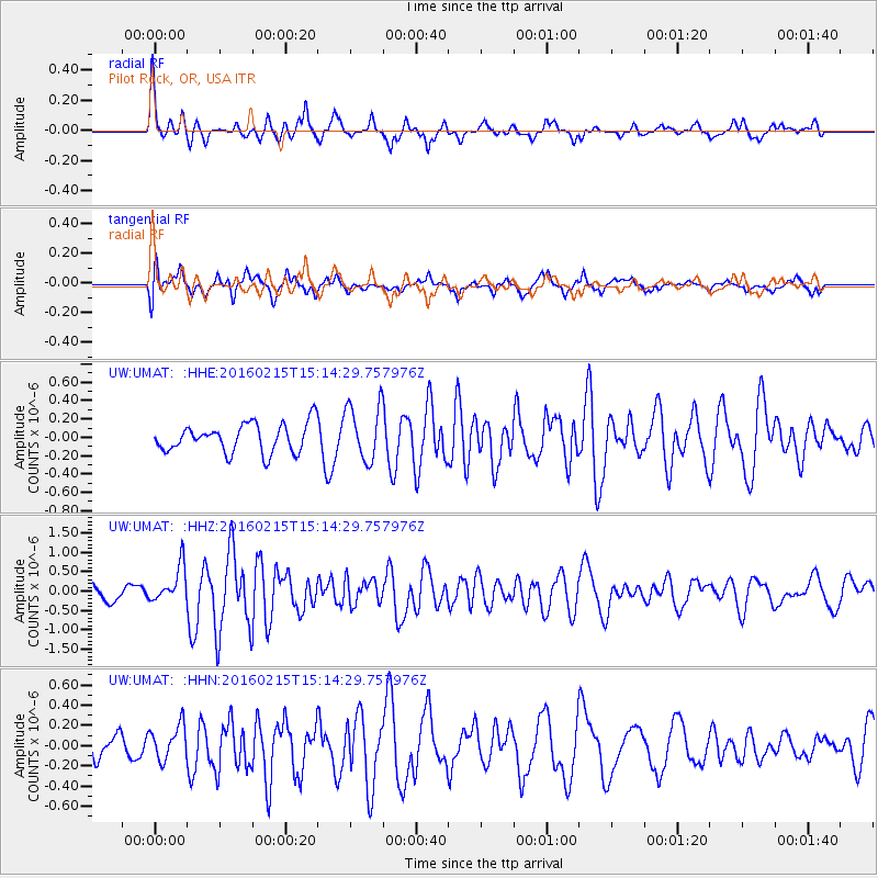
UMAT Pilot Rock, OR, USA - Earthquake Result Viewer
*The percent match for this event was below the threshold and hence no stack was calculated.
| Earthquake location: |
Tonga Islands |
| Earthquake latitude/longitude: |
-21.0/-175.5 |
| Earthquake time(UTC): |
2016/02/15 (046) 15:02:33 GMT |
| Earthquake Depth: |
10 km |
| Earthquake Magnitude: |
5.7 MB |
| Earthquake Catalog/Contributor: |
NEIC PDE/NEIC COMCAT |
|
| Network: |
UW Pacific Northwest Regional Seismic Network |
| Station: |
UMAT Pilot Rock, OR, USA |
| Lat/Lon: |
45.29 N/118.96 W |
| Elevation: |
1318 m |
|
| Distance: |
83.6 deg |
| Az: |
36.35 deg |
| Baz: |
231.677 deg |
| Ray Param: |
$rayparam |
*The percent match for this event was below the threshold and hence was not used in the summary stack. |
|
| Radial Match: |
68.69796 % |
| Radial Bump: |
352 |
| Transverse Match: |
65.643906 % |
| Transverse Bump: |
400 |
| SOD ConfigId: |
7422571 |
| Insert Time: |
2019-04-21 22:29:53.491 +0000 |
| GWidth: |
2.5 |
| Max Bumps: |
400 |
| Tol: |
0.001 |
|
Signal To Noise
| Channel | StoN | STA | LTA |
| UW:UMAT: :HHZ:20160215T15:14:29.757976Z | 3.1324172 | 4.6634747E-7 | 1.4887783E-7 |
| UW:UMAT: :HHN:20160215T15:14:29.757976Z | 0.8681539 | 1.6645792E-7 | 1.9173781E-7 |
| UW:UMAT: :HHE:20160215T15:14:29.757976Z | 1.9916087 | 3.1272626E-7 | 1.5702194E-7 |
| Arrivals |
| Ps | |
| PpPs | |
| PsPs/PpSs | |


