WMQ Urumqi, Xinjiang Province, China - Earthquake Result Viewer
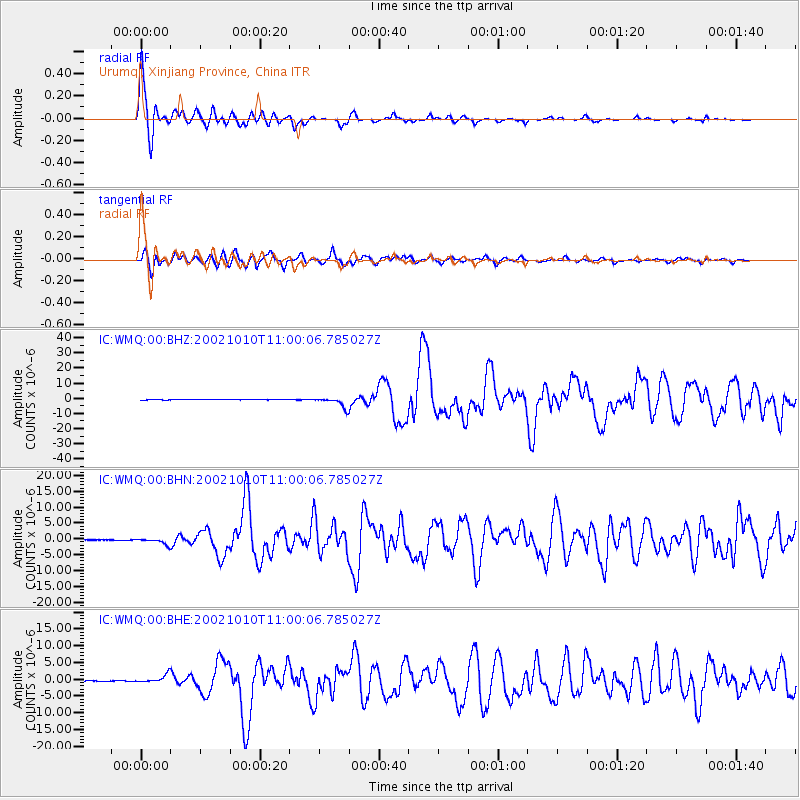
Earthquake location: Irian Jaya Region, Indonesia
Earthquake latitude/longitude: -1.8/134.3
Earthquake time(UTC): 2002/10/10 (283) 10:50:20 GMT
Earthquake Depth: 10 km
Earthquake Magnitude: 6.5 MB, 7.7 MS, 7.6 MW, 7.4 MW
Earthquake Catalog/Contributor: WHDF/NEIC
Network: IC New China Digital Seismograph Network
Station: WMQ Urumqi, Xinjiang Province, China
Lat/Lon: 43.82 N/87.69 E
Elevation: 903 m
Distance: 61.6 deg
Az: 323.27 deg
Baz: 124.325 deg
Ray Param: 0.06078877
Estimated Moho Depth: 49.25 km
Estimated Crust Vp/Vs: 1.69
Assumed Crust Vp: 6.242 km/s
Estimated Crust Vs: 3.704 km/s
Estimated Crust Poisson's Ratio: 0.23
Radial Match: 96.70912 %
Radial Bump: 317
Transverse Match: 90.22985 %
Transverse Bump: 400
SOD ConfigId: 4714
Insert Time: 2010-03-05 00:04:26.311 +0000
GWidth: 2.5
Max Bumps: 400
Tol: 0.001

Signal To Noise

ChannelStoNSTALTA
IC:WMQ:00:BHN:20021010T11:00:06.785027Z13.896649.4223304E-76.780294E-8
IC:WMQ:00:BHE:20021010T11:00:06.785027Z14.6122071.2340878E-68.445595E-8
IC:WMQ:00:BHZ:20021010T11:00:06.785027Z24.8685253.3605913E-61.3513431E-7
Arrivals
Ps5.7 SECOND
PpPs20 SECOND
PsPs/PpSs26 SECOND