You are here: Home > Network List > US - United States National Seismic Network Stations List
> Station WVOR Wild Horse Valley, Oregon, USA > Earthquake Result Viewer
WVOR Wild Horse Valley, Oregon, USA - Earthquake Result Viewer
| Earthquake location: |
Solomon Islands |
| Earthquake latitude/longitude: |
-9.3/158.4 |
| Earthquake time(UTC): |
2015/07/10 (191) 04:12:41 GMT |
| Earthquake Depth: |
10 km |
| Earthquake Magnitude: |
6.7 MWW, 6.6 MWB, 6.7 MWC, 7.0 MI |
| Earthquake Catalog/Contributor: |
NEIC PDE/NEIC COMCAT |
|
| Network: |
US United States National Seismic Network |
| Station: |
WVOR Wild Horse Valley, Oregon, USA |
| Lat/Lon: |
42.43 N/118.64 W |
| Elevation: |
1344 m |
|
| Distance: |
91.0 deg |
| Az: |
47.292 deg |
| Baz: |
258.427 deg |
| Ray Param: |
0.041629896 |
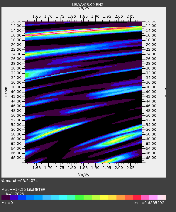
| Estimated Moho Depth: |
14.25 km |
| Estimated Crust Vp/Vs: |
1.78 |
| Assumed Crust Vp: |
6.279 km/s |
| Estimated Crust Vs: |
3.522 km/s |
| Estimated Crust Poisson's Ratio: |
0.27 |
|
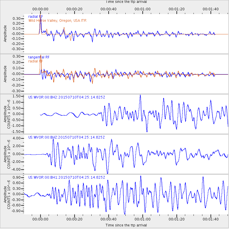
| Radial Match: |
93.24074 % |
| Radial Bump: |
386 |
| Transverse Match: |
91.04289 % |
| Transverse Bump: |
400 |
| SOD ConfigId: |
1080791 |
| Insert Time: |
2015-07-24 04:40:48.528 +0000 |
| GWidth: |
2.5 |
| Max Bumps: |
400 |
| Tol: |
0.001 |
|
Signal To Noise
| Channel | StoN | STA | LTA |
| US:WVOR:00:BHZ:20150710T04:25:14.825Z | 2.1780603 | 1.61137E-7 | 7.398189E-8 |
| US:WVOR:00:BH1:20150710T04:25:14.825Z | 0.80473906 | 4.6332836E-8 | 5.7574983E-8 |
| US:WVOR:00:BH2:20150710T04:25:14.825Z | 0.6188409 | 6.5039565E-8 | 1.0509901E-7 |
| Arrivals |
| Ps | 1.8 SECOND |
| PpPs | 6.2 SECOND |
| PsPs/PpSs | 8.0 SECOND |


