You are here: Home > Network List > TA - USArray Transportable Network (new EarthScope stations) Stations List
> Station G03D McMinnville, OR, USA > Earthquake Result Viewer
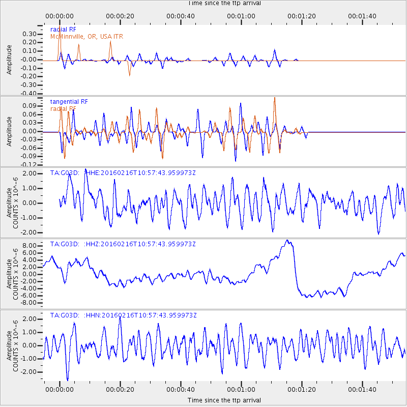
G03D McMinnville, OR, USA - Earthquake Result Viewer
*The percent match for this event was below the threshold and hence no stack was calculated.
| Earthquake location: |
Near Coast Of Peru |
| Earthquake latitude/longitude: |
-16.4/-73.5 |
| Earthquake time(UTC): |
2016/02/16 (047) 10:46:27 GMT |
| Earthquake Depth: |
13 km |
| Earthquake Magnitude: |
5.7 MWW, 5.6 MWB, 5.7 MWC |
| Earthquake Catalog/Contributor: |
NEIC PDE/NEIC COMCAT |
|
| Network: |
TA USArray Transportable Network (new EarthScope stations) |
| Station: |
G03D McMinnville, OR, USA |
| Lat/Lon: |
45.21 N/123.26 W |
| Elevation: |
222 m |
|
| Distance: |
76.1 deg |
| Az: |
326.256 deg |
| Baz: |
131.047 deg |
| Ray Param: |
$rayparam |
*The percent match for this event was below the threshold and hence was not used in the summary stack. |
|
| Radial Match: |
49.302322 % |
| Radial Bump: |
400 |
| Transverse Match: |
56.926205 % |
| Transverse Bump: |
400 |
| SOD ConfigId: |
7422571 |
| Insert Time: |
2019-04-21 22:38:44.001 +0000 |
| GWidth: |
2.5 |
| Max Bumps: |
400 |
| Tol: |
0.001 |
|
Signal To Noise
| Channel | StoN | STA | LTA |
| TA:G03D: :HHZ:20160216T10:57:43.959973Z | 0.6427657 | 5.4015436E-6 | 8.403596E-6 |
| TA:G03D: :HHN:20160216T10:57:43.959973Z | 1.6472433 | 1.1544744E-6 | 7.0085235E-7 |
| TA:G03D: :HHE:20160216T10:57:43.959973Z | 0.68018275 | 5.940028E-7 | 8.7329886E-7 |
| Arrivals |
| Ps | |
| PpPs | |
| PsPs/PpSs | |


