You are here: Home > Network List > UU - University of Utah Regional Network Stations List
> Station WPUT Wasatch Plateau, UT,USA > Earthquake Result Viewer
WPUT Wasatch Plateau, UT,USA - Earthquake Result Viewer
| Earthquake location: |
Solomon Islands |
| Earthquake latitude/longitude: |
-9.3/158.4 |
| Earthquake time(UTC): |
2015/07/10 (191) 04:12:41 GMT |
| Earthquake Depth: |
10 km |
| Earthquake Magnitude: |
6.7 MWW, 6.6 MWB, 6.7 MWC, 7.0 MI |
| Earthquake Catalog/Contributor: |
NEIC PDE/NEIC COMCAT |
|
| Network: |
UU University of Utah Regional Network |
| Station: |
WPUT Wasatch Plateau, UT,USA |
| Lat/Lon: |
39.00 N/111.36 W |
| Elevation: |
2618 m |
|
| Distance: |
96.0 deg |
| Az: |
51.578 deg |
| Baz: |
262.9 deg |
| Ray Param: |
0.040645897 |
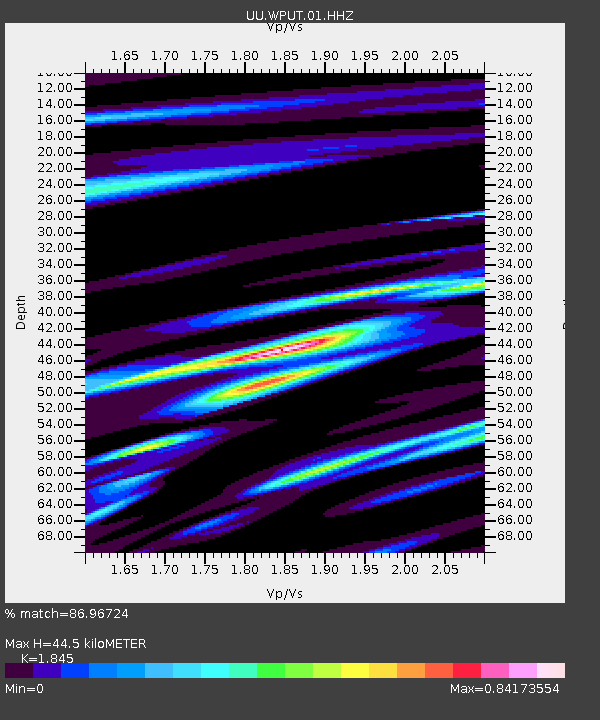
| Estimated Moho Depth: |
44.5 km |
| Estimated Crust Vp/Vs: |
1.85 |
| Assumed Crust Vp: |
6.207 km/s |
| Estimated Crust Vs: |
3.364 km/s |
| Estimated Crust Poisson's Ratio: |
0.29 |
|
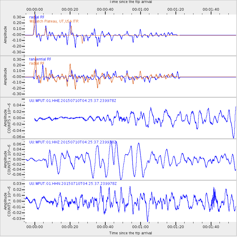
| Radial Match: |
86.96724 % |
| Radial Bump: |
327 |
| Transverse Match: |
78.75467 % |
| Transverse Bump: |
400 |
| SOD ConfigId: |
1080791 |
| Insert Time: |
2015-07-24 04:41:33.000 +0000 |
| GWidth: |
2.5 |
| Max Bumps: |
400 |
| Tol: |
0.001 |
|
Signal To Noise
| Channel | StoN | STA | LTA |
| UU:WPUT:01:HHZ:20150710T04:25:37.239978Z | 0.69301295 | 2.7648042E-9 | 3.989542E-9 |
| UU:WPUT:01:HHN:20150710T04:25:37.239978Z | 1.5428517 | 6.6843615E-9 | 4.3324717E-9 |
| UU:WPUT:01:HHE:20150710T04:25:37.239978Z | 1.6700134 | 4.8286664E-9 | 2.8913938E-9 |
| Arrivals |
| Ps | 6.2 SECOND |
| PpPs | 20 SECOND |
| PsPs/PpSs | 26 SECOND |


