You are here: Home > Network List > IC - New China Digital Seismograph Network Stations List
> Station WMQ Urumqi, Xinjiang Province, China > Earthquake Result Viewer
WMQ Urumqi, Xinjiang Province, China - Earthquake Result Viewer
| Earthquake location: |
New Ireland Region, P.N.G. |
| Earthquake latitude/longitude: |
-5.3/153.7 |
| Earthquake time(UTC): |
2003/01/10 (010) 13:11:56 GMT |
| Earthquake Depth: |
72 km |
| Earthquake Magnitude: |
5.9 MB, 6.7 MW, 6.6 MW |
| Earthquake Catalog/Contributor: |
WHDF/NEIC |
|
| Network: |
IC New China Digital Seismograph Network |
| Station: |
WMQ Urumqi, Xinjiang Province, China |
| Lat/Lon: |
43.82 N/87.69 E |
| Elevation: |
903 m |
|
| Distance: |
76.7 deg |
| Az: |
317.2 deg |
| Baz: |
110.82 deg |
| Ray Param: |
0.050650507 |
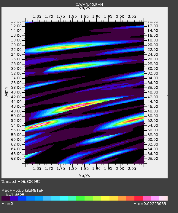
| Estimated Moho Depth: |
53.5 km |
| Estimated Crust Vp/Vs: |
1.66 |
| Assumed Crust Vp: |
6.242 km/s |
| Estimated Crust Vs: |
3.755 km/s |
| Estimated Crust Poisson's Ratio: |
0.22 |
|
| Radial Match: |
96.300995 % |
| Radial Bump: |
400 |
| Transverse Match: |
93.3218 % |
| Transverse Bump: |
400 |
| SOD ConfigId: |
4714 |
| Insert Time: |
2010-03-05 00:05:19.922 +0000 |
| GWidth: |
2.5 |
| Max Bumps: |
400 |
| Tol: |
0.001 |
|

Signal To Noise
| Channel | StoN | STA | LTA |
| IC:WMQ:00:BHN:20030110T13:23:09.410Z | 5.8838134 | 3.3827624E-7 | 5.7492684E-8 |
| IC:WMQ:00:BHE:20030110T13:23:09.410Z | 17.626228 | 7.9997307E-7 | 4.5385377E-8 |
| IC:WMQ:00:BHZ:20030110T13:23:09.410Z | 49.598125 | 2.801322E-6 | 5.64804E-8 |
| Arrivals |
| Ps | 5.9 SECOND |
| PpPs | 22 SECOND |
| PsPs/PpSs | 28 SECOND |


