You are here: Home > Network List > AV - Alaska Volcano Observatory Stations List
> Station SPCR Ckakachatna River, Mount Spurr, Alaska > Earthquake Result Viewer
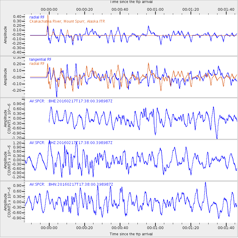
SPCR Ckakachatna River, Mount Spurr, Alaska - Earthquake Result Viewer
*The percent match for this event was below the threshold and hence no stack was calculated.
| Earthquake location: |
Halmahera, Indonesia |
| Earthquake latitude/longitude: |
0.9/129.1 |
| Earthquake time(UTC): |
2016/02/17 (048) 17:26:03 GMT |
| Earthquake Depth: |
10 km |
| Earthquake Magnitude: |
5.8 MB |
| Earthquake Catalog/Contributor: |
NEIC PDE/NEIC ALERT |
|
| Network: |
AV Alaska Volcano Observatory |
| Station: |
SPCR Ckakachatna River, Mount Spurr, Alaska |
| Lat/Lon: |
61.20 N/152.21 W |
| Elevation: |
984 m |
|
| Distance: |
83.8 deg |
| Az: |
28.533 deg |
| Baz: |
260.507 deg |
| Ray Param: |
$rayparam |
*The percent match for this event was below the threshold and hence was not used in the summary stack. |
|
| Radial Match: |
61.536865 % |
| Radial Bump: |
400 |
| Transverse Match: |
60.65496 % |
| Transverse Bump: |
400 |
| SOD ConfigId: |
7422571 |
| Insert Time: |
2019-04-21 22:47:25.882 +0000 |
| GWidth: |
2.5 |
| Max Bumps: |
400 |
| Tol: |
0.001 |
|
Signal To Noise
| Channel | StoN | STA | LTA |
| AV:SPCR: :BHZ:20160217T17:38:00.398987Z | 1.9322189 | 7.243555E-7 | 3.7488275E-7 |
| AV:SPCR: :BHN:20160217T17:38:00.398987Z | 1.0506432 | 2.6402245E-7 | 2.51296E-7 |
| AV:SPCR: :BHE:20160217T17:38:00.398987Z | 0.8574793 | 2.7333914E-7 | 3.1877056E-7 |
| Arrivals |
| Ps | |
| PpPs | |
| PsPs/PpSs | |


