You are here: Home > Network List > KN - Kyrgyz Seismic Telemetry Network Stations List
> Station UCH - > Earthquake Result Viewer
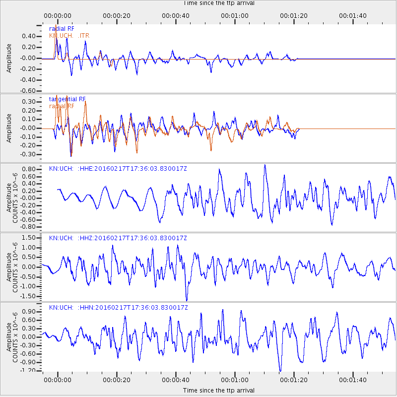
UCH - - Earthquake Result Viewer
*The percent match for this event was below the threshold and hence no stack was calculated.
| Earthquake location: |
Halmahera, Indonesia |
| Earthquake latitude/longitude: |
0.9/129.1 |
| Earthquake time(UTC): |
2016/02/17 (048) 17:26:03 GMT |
| Earthquake Depth: |
10 km |
| Earthquake Magnitude: |
5.8 MB |
| Earthquake Catalog/Contributor: |
NEIC PDE/NEIC ALERT |
|
| Network: |
KN Kyrgyz Seismic Telemetry Network |
| Station: |
UCH - |
| Lat/Lon: |
42.23 N/74.51 E |
| Elevation: |
3850 m |
|
| Distance: |
63.9 deg |
| Az: |
317.616 deg |
| Baz: |
114.838 deg |
| Ray Param: |
$rayparam |
*The percent match for this event was below the threshold and hence was not used in the summary stack. |
|
| Radial Match: |
63.56482 % |
| Radial Bump: |
352 |
| Transverse Match: |
53.284683 % |
| Transverse Bump: |
400 |
| SOD ConfigId: |
7422571 |
| Insert Time: |
2019-04-21 22:48:18.238 +0000 |
| GWidth: |
2.5 |
| Max Bumps: |
400 |
| Tol: |
0.001 |
|
Signal To Noise
| Channel | StoN | STA | LTA |
| KN:UCH: :HHZ:20160217T17:36:03.830017Z | 2.1637459 | 3.0516807E-7 | 1.4103694E-7 |
| KN:UCH: :HHN:20160217T17:36:03.830017Z | 1.4897281 | 2.0261797E-7 | 1.3601003E-7 |
| KN:UCH: :HHE:20160217T17:36:03.830017Z | 2.3941646 | 3.5872654E-7 | 1.4983371E-7 |
| Arrivals |
| Ps | |
| PpPs | |
| PsPs/PpSs | |


