You are here: Home > Network List > IC - New China Digital Seismograph Network Stations List
> Station WMQ Urumqi, Xinjiang Province, China > Earthquake Result Viewer
WMQ Urumqi, Xinjiang Province, China - Earthquake Result Viewer

| Earthquake location: |
Flores Region, Indonesia |
| Earthquake latitude/longitude: |
-8.3/120.7 |
| Earthquake time(UTC): |
2003/03/25 (084) 02:53:25 GMT |
| Earthquake Depth: |
33 km |
| Earthquake Magnitude: |
6.2 MB, 6.1 MS, 6.5 MW, 6.3 MW |
| Earthquake Catalog/Contributor: |
WHDF/NEIC |
|
| Network: |
IC New China Digital Seismograph Network |
| Station: |
WMQ Urumqi, Xinjiang Province, China |
| Lat/Lon: |
43.82 N/87.69 E |
| Elevation: |
903 m |
|
| Distance: |
59.9 deg |
| Az: |
332.853 deg |
| Baz: |
141.401 deg |
| Ray Param: |
0.061831873 |
| Estimated Moho Depth: |
49.0 km |
| Estimated Crust Vp/Vs: |
1.81 |
| Assumed Crust Vp: |
6.242 km/s |
| Estimated Crust Vs: |
3.444 km/s |
| Estimated Crust Poisson's Ratio: |
0.28 |
|
| Radial Match: |
95.594246 % |
| Radial Bump: |
400 |
| Transverse Match: |
89.471085 % |
| Transverse Bump: |
400 |
| SOD ConfigId: |
4714 |
| Insert Time: |
2010-03-05 00:05:31.045 +0000 |
| GWidth: |
2.5 |
| Max Bumps: |
400 |
| Tol: |
0.001 |
|
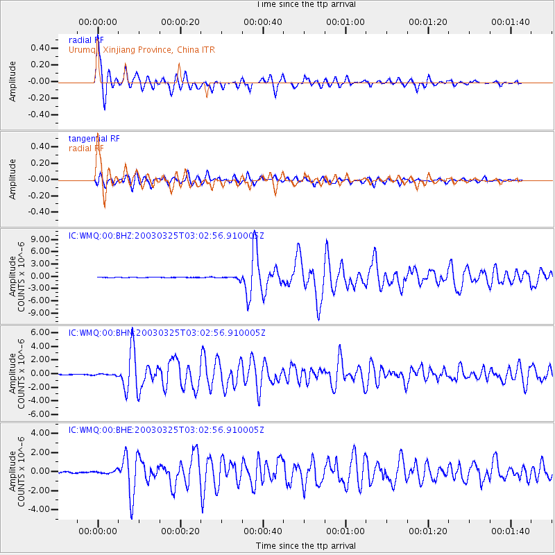
Signal To Noise
| Channel | StoN | STA | LTA |
| IC:WMQ:00:BHN:20030325T03:02:56.910005Z | 1.8298264 | 1.1505532E-7 | 6.287773E-8 |
| IC:WMQ:00:BHE:20030325T03:02:56.910005Z | 2.8274114 | 1.6043766E-7 | 5.674366E-8 |
| IC:WMQ:00:BHZ:20030325T03:02:56.910005Z | 5.6940317 | 3.5719117E-7 | 6.27308E-8 |
| Arrivals |
| Ps | 6.7 SECOND |
| PpPs | 21 SECOND |
| PsPs/PpSs | 28 SECOND |


