You are here: Home > Network List > CI - Caltech Regional Seismic Network Stations List
> Station BAR Barrett, Tecate, CA, USA > Earthquake Result Viewer
BAR Barrett, Tecate, CA, USA - Earthquake Result Viewer
| Earthquake location: |
Rat Islands, Aleutian Islands |
| Earthquake latitude/longitude: |
51.4/176.8 |
| Earthquake time(UTC): |
2003/06/23 (174) 12:12:34 GMT |
| Earthquake Depth: |
20 km |
| Earthquake Magnitude: |
6.3 MB, 7.0 MS, 6.9 MW, 6.8 MW |
| Earthquake Catalog/Contributor: |
WHDF/NEIC |
|
| Network: |
CI Caltech Regional Seismic Network |
| Station: |
BAR Barrett, Tecate, CA, USA |
| Lat/Lon: |
32.68 N/116.67 W |
| Elevation: |
521 m |
|
| Distance: |
51.0 deg |
| Az: |
84.496 deg |
| Baz: |
312.375 deg |
| Ray Param: |
0.067658305 |
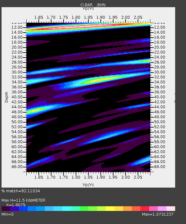
| Estimated Moho Depth: |
11.5 km |
| Estimated Crust Vp/Vs: |
1.81 |
| Assumed Crust Vp: |
6.264 km/s |
| Estimated Crust Vs: |
3.465 km/s |
| Estimated Crust Poisson's Ratio: |
0.28 |
|
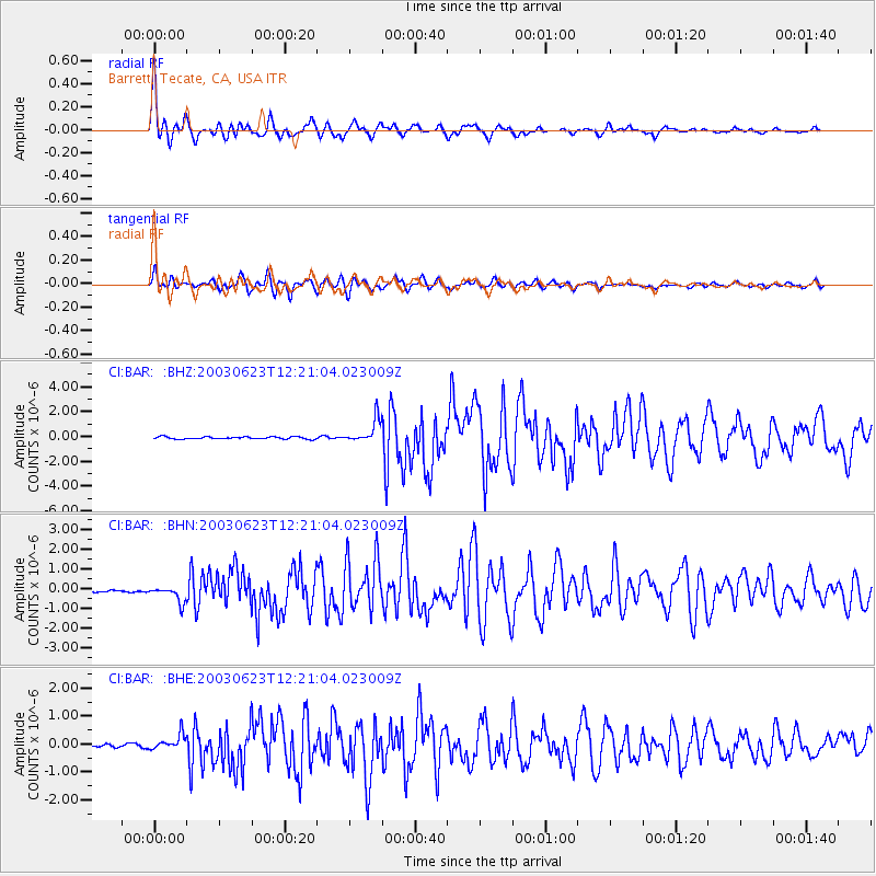
| Radial Match: |
92.11034 % |
| Radial Bump: |
400 |
| Transverse Match: |
89.983864 % |
| Transverse Bump: |
400 |
| SOD ConfigId: |
3787 |
| Insert Time: |
2010-02-26 00:07:54.910 +0000 |
| GWidth: |
2.5 |
| Max Bumps: |
400 |
| Tol: |
0.001 |
|
Signal To Noise
| Channel | StoN | STA | LTA |
| CI:BAR: :BHN:20030623T12:21:04.023009Z | 4.7408853 | 4.0852134E-7 | 8.616985E-8 |
| CI:BAR: :BHE:20030623T12:21:04.023009Z | 3.6958885 | 2.687624E-7 | 7.2719295E-8 |
| CI:BAR: :BHZ:20030623T12:21:04.023009Z | 10.10093 | 9.2319954E-7 | 9.139748E-8 |
| Arrivals |
| Ps | 1.6 SECOND |
| PpPs | 4.9 SECOND |
| PsPs/PpSs | 6.5 SECOND |


