You are here: Home > Network List > XL12 - Hangay Dome, Mongolia Stations List
> Station HV14 HV14 > Earthquake Result Viewer
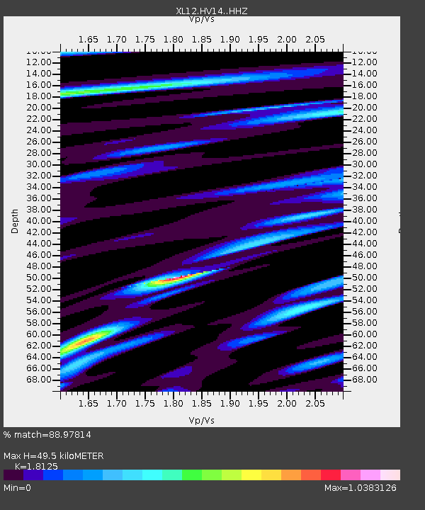
HV14 HV14 - Earthquake Result Viewer
| Earthquake location: |
Halmahera, Indonesia |
| Earthquake latitude/longitude: |
0.9/129.1 |
| Earthquake time(UTC): |
2016/02/17 (048) 17:26:03 GMT |
| Earthquake Depth: |
10 km |
| Earthquake Magnitude: |
5.8 MB |
| Earthquake Catalog/Contributor: |
NEIC PDE/NEIC ALERT |
|
| Network: |
XL Hangay Dome, Mongolia |
| Station: |
HV14 HV14 |
| Lat/Lon: |
50.46 N/100.17 E |
| Elevation: |
1663 m |
|
| Distance: |
55.2 deg |
| Az: |
337.89 deg |
| Baz: |
143.931 deg |
| Ray Param: |
0.06496386 |
| Estimated Moho Depth: |
49.5 km |
| Estimated Crust Vp/Vs: |
1.81 |
| Assumed Crust Vp: |
6.419 km/s |
| Estimated Crust Vs: |
3.542 km/s |
| Estimated Crust Poisson's Ratio: |
0.28 |
|
| Radial Match: |
88.97814 % |
| Radial Bump: |
394 |
| Transverse Match: |
61.224472 % |
| Transverse Bump: |
400 |
| SOD ConfigId: |
7422571 |
| Insert Time: |
2019-04-21 22:49:29.103 +0000 |
| GWidth: |
2.5 |
| Max Bumps: |
400 |
| Tol: |
0.001 |
|

Signal To Noise
| Channel | StoN | STA | LTA |
| XL:HV14: :HHZ:20160217T17:35:04.099976Z | 3.8244803 | 3.6275384E-7 | 9.485049E-8 |
| XL:HV14: :HHN:20160217T17:35:04.099976Z | 1.7236826 | 1.4000375E-7 | 8.1223625E-8 |
| XL:HV14: :HHE:20160217T17:35:04.099976Z | 1.2547836 | 8.153098E-8 | 6.497612E-8 |
| Arrivals |
| Ps | 6.6 SECOND |
| PpPs | 21 SECOND |
| PsPs/PpSs | 27 SECOND |


