You are here: Home > Network List > XL12 - Hangay Dome, Mongolia Stations List
> Station HV17 HV17 > Earthquake Result Viewer
HV17 HV17 - Earthquake Result Viewer
| Earthquake location: |
Halmahera, Indonesia |
| Earthquake latitude/longitude: |
0.9/129.1 |
| Earthquake time(UTC): |
2016/02/17 (048) 17:26:03 GMT |
| Earthquake Depth: |
10 km |
| Earthquake Magnitude: |
5.8 MB |
| Earthquake Catalog/Contributor: |
NEIC PDE/NEIC ALERT |
|
| Network: |
XL Hangay Dome, Mongolia |
| Station: |
HV17 HV17 |
| Lat/Lon: |
50.54 N/100.40 E |
| Elevation: |
1692 m |
|
| Distance: |
55.2 deg |
| Az: |
338.091 deg |
| Baz: |
144.222 deg |
| Ray Param: |
0.064978406 |
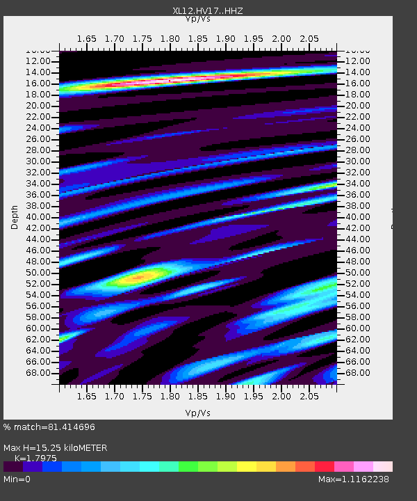
| Estimated Moho Depth: |
15.25 km |
| Estimated Crust Vp/Vs: |
1.80 |
| Assumed Crust Vp: |
6.419 km/s |
| Estimated Crust Vs: |
3.571 km/s |
| Estimated Crust Poisson's Ratio: |
0.28 |
|
| Radial Match: |
81.414696 % |
| Radial Bump: |
400 |
| Transverse Match: |
62.45432 % |
| Transverse Bump: |
400 |
| SOD ConfigId: |
7422571 |
| Insert Time: |
2019-04-21 22:49:31.367 +0000 |
| GWidth: |
2.5 |
| Max Bumps: |
400 |
| Tol: |
0.001 |
|

Signal To Noise
| Channel | StoN | STA | LTA |
| XL:HV17: :HHZ:20160217T17:35:03.940002Z | 3.5161505 | 3.5015267E-7 | 9.958409E-8 |
| XL:HV17: :HHN:20160217T17:35:03.940002Z | 1.1954154 | 1.0738958E-7 | 8.9834536E-8 |
| XL:HV17: :HHE:20160217T17:35:03.940002Z | 1.974161 | 1.1056866E-7 | 5.600792E-8 |
| Arrivals |
| Ps | 2.0 SECOND |
| PpPs | 6.3 SECOND |
| PsPs/PpSs | 8.3 SECOND |


