You are here: Home > Network List > XL12 - Hangay Dome, Mongolia Stations List
> Station HV18 HV18 > Earthquake Result Viewer
HV18 HV18 - Earthquake Result Viewer
| Earthquake location: |
Halmahera, Indonesia |
| Earthquake latitude/longitude: |
0.9/129.1 |
| Earthquake time(UTC): |
2016/02/17 (048) 17:26:03 GMT |
| Earthquake Depth: |
10 km |
| Earthquake Magnitude: |
5.8 MB |
| Earthquake Catalog/Contributor: |
NEIC PDE/NEIC ALERT |
|
| Network: |
XL Hangay Dome, Mongolia |
| Station: |
HV18 HV18 |
| Lat/Lon: |
50.57 N/100.62 E |
| Elevation: |
1696 m |
|
| Distance: |
55.1 deg |
| Az: |
338.258 deg |
| Baz: |
144.489 deg |
| Ray Param: |
0.06501364 |
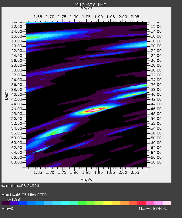
| Estimated Moho Depth: |
46.25 km |
| Estimated Crust Vp/Vs: |
1.88 |
| Assumed Crust Vp: |
6.419 km/s |
| Estimated Crust Vs: |
3.414 km/s |
| Estimated Crust Poisson's Ratio: |
0.30 |
|
| Radial Match: |
85.34926 % |
| Radial Bump: |
400 |
| Transverse Match: |
46.514233 % |
| Transverse Bump: |
400 |
| SOD ConfigId: |
7422571 |
| Insert Time: |
2019-04-21 22:49:31.410 +0000 |
| GWidth: |
2.5 |
| Max Bumps: |
400 |
| Tol: |
0.001 |
|

Signal To Noise
| Channel | StoN | STA | LTA |
| XL:HV18: :HHZ:20160217T17:35:03.559021Z | 2.68422 | 3.0269086E-7 | 1.1276678E-7 |
| XL:HV18: :HHN:20160217T17:35:03.559021Z | 0.9264718 | 1.1030059E-7 | 1.1905445E-7 |
| XL:HV18: :HHE:20160217T17:35:03.559021Z | 2.3970008 | 2.0618943E-7 | 8.601976E-8 |
| Arrivals |
| Ps | 6.7 SECOND |
| PpPs | 20 SECOND |
| PsPs/PpSs | 26 SECOND |


