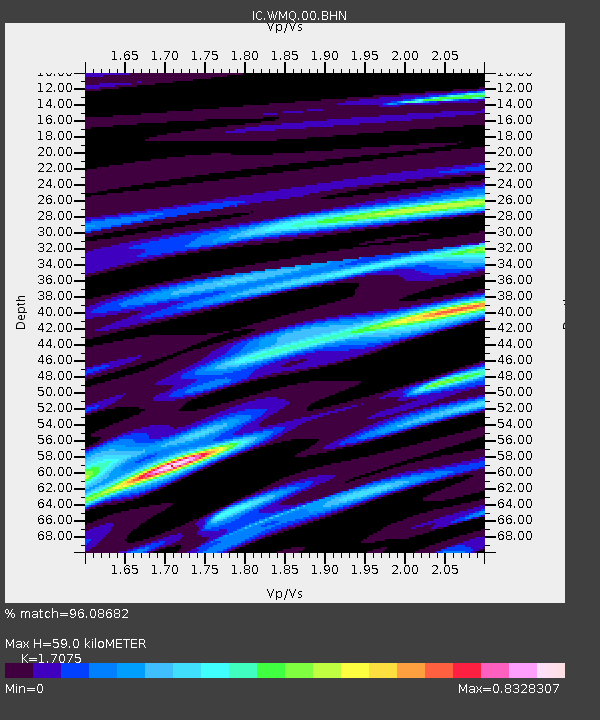
WMQ Urumqi, Xinjiang Province, China - Earthquake Result Viewer
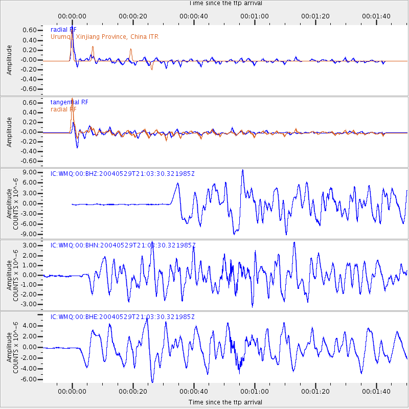
Earthquake location: Off East Coast Of Honshu, Japan
Earthquake latitude/longitude: 34.3/141.4
Earthquake time(UTC): 2004/05/29 (150) 20:56:09 GMT
Earthquake Depth: 16 km
Earthquake Magnitude: 5.6 MB, 6.6 MS, 6.5 MW, 6.3 MW
Earthquake Catalog/Contributor: WHDF/NEIC
Network: IC New China Digital Seismograph Network
Station: WMQ Urumqi, Xinjiang Province, China
Lat/Lon: 43.82 N/87.69 E
Elevation: 903 m
Distance: 42.1 deg
Az: 299.607 deg
Baz: 84.249 deg
Ray Param: 0.073326744
Estimated Moho Depth: 59.0 km
Estimated Crust Vp/Vs: 1.71
Assumed Crust Vp: 6.242 km/s
Estimated Crust Vs: 3.656 km/s
Estimated Crust Poisson's Ratio: 0.24
Radial Match: 96.08682 %
Radial Bump: 326
Transverse Match: 92.314514 %
Transverse Bump: 400
SOD ConfigId: 2459
Insert Time: 2010-03-05 00:06:21.672 +0000
GWidth: 2.5
Max Bumps: 400
Tol: 0.001

Signal To Noise

ChannelStoNSTALTA
IC:WMQ:00:BHN:20040529T21:03:30.321985Z1.22950668.1296406E-86.612116E-8
IC:WMQ:00:BHE:20040529T21:03:30.321985Z22.4824771.3396199E-65.9585066E-8
IC:WMQ:00:BHZ:20040529T21:03:30.321985Z32.1580622.4542246E-67.6317555E-8
Arrivals
Ps7.1 SECOND
PpPs24 SECOND
PsPs/PpSs31 SECOND