WMQ Urumqi, Xinjiang Province, China - Earthquake Result Viewer
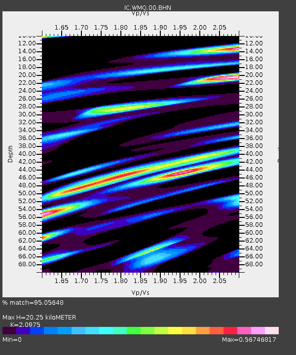
Earthquake location: Irian Jaya Region, Indonesia
Earthquake latitude/longitude: -0.4/133.1
Earthquake time(UTC): 2004/07/28 (210) 03:56:28 GMT
Earthquake Depth: 13 km
Earthquake Magnitude: 6.0 MB, 6.3 MS, 6.5 MW, 6.4 MW
Earthquake Catalog/Contributor: WHDF/NEIC
Network: IC New China Digital Seismograph Network
Station: WMQ Urumqi, Xinjiang Province, China
Lat/Lon: 43.82 N/87.69 E
Elevation: 903 m
Distance: 59.8 deg
Az: 323.398 deg
Baz: 124.54 deg
Ray Param: 0.061940223
Estimated Moho Depth: 20.25 km
Estimated Crust Vp/Vs: 2.10
Assumed Crust Vp: 6.242 km/s
Estimated Crust Vs: 2.976 km/s
Estimated Crust Poisson's Ratio: 0.35
Radial Match: 95.05648 %
Radial Bump: 400
Transverse Match: 88.77815 %
Transverse Bump: 400
SOD ConfigId: 2459
Insert Time: 2010-03-05 00:07:22.388 +0000
GWidth: 2.5
Max Bumps: 400
Tol: 0.001

Signal To Noise

ChannelStoNSTALTA
IC:WMQ:00:BHN:20040728T04:06:02.261011Z16.051177.564608E-74.712808E-8
IC:WMQ:00:BHE:20040728T04:06:02.261011Z20.5520041.0014899E-64.872955E-8
IC:WMQ:00:BHZ:20040728T04:06:02.261011Z40.119122.3710652E-65.910063E-8
Arrivals
Ps3.7 SECOND
PpPs9.7 SECOND
PsPs/PpSs13 SECOND