You are here: Home > Network List > IC - New China Digital Seismograph Network Stations List
> Station WMQ Urumqi, Xinjiang Province, China > Earthquake Result Viewer
WMQ Urumqi, Xinjiang Province, China - Earthquake Result Viewer

| Earthquake location: |
Irian Jaya Region, Indonesia |
| Earthquake latitude/longitude: |
-3.0/136.3 |
| Earthquake time(UTC): |
1998/04/27 (117) 18:40:38 GMT |
| Earthquake Depth: |
53 km |
| Earthquake Magnitude: |
5.5 MB, 6.2 UNKNOWN, 6.0 MW |
| Earthquake Catalog/Contributor: |
WHDF/NEIC |
|
| Network: |
IC New China Digital Seismograph Network |
| Station: |
WMQ Urumqi, Xinjiang Province, China |
| Lat/Lon: |
43.82 N/87.69 E |
| Elevation: |
903 m |
|
| Distance: |
63.7 deg |
| Az: |
322.751 deg |
| Baz: |
123.374 deg |
| Ray Param: |
0.059257604 |
| Estimated Moho Depth: |
20.25 km |
| Estimated Crust Vp/Vs: |
1.75 |
| Assumed Crust Vp: |
6.242 km/s |
| Estimated Crust Vs: |
3.567 km/s |
| Estimated Crust Poisson's Ratio: |
0.26 |
|
| Radial Match: |
95.51577 % |
| Radial Bump: |
400 |
| Transverse Match: |
88.01801 % |
| Transverse Bump: |
400 |
| SOD ConfigId: |
4480 |
| Insert Time: |
2010-03-05 00:08:13.477 +0000 |
| GWidth: |
2.5 |
| Max Bumps: |
400 |
| Tol: |
0.001 |
|
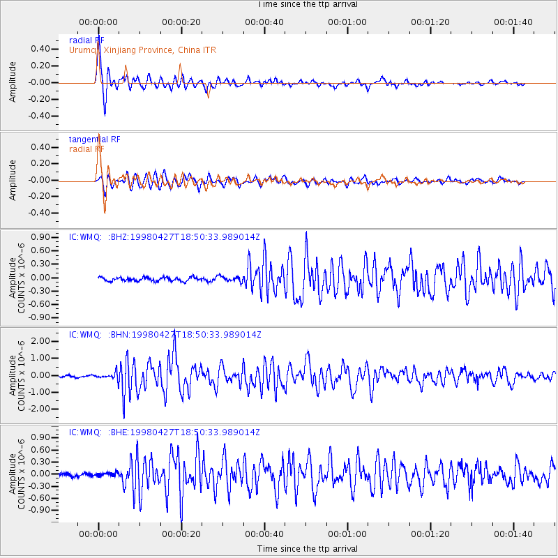
Signal To Noise
| Channel | StoN | STA | LTA |
| IC:WMQ: :BHN:19980427T18:50:33.989014Z | 4.415896 | 1.9639177E-7 | 4.4473822E-8 |
| IC:WMQ: :BHE:19980427T18:50:33.989014Z | 1.1278068 | 4.378021E-8 | 3.881889E-8 |
| IC:WMQ: :BHZ:19980427T18:50:33.989014Z | 1.3904585 | 5.7009743E-8 | 4.100068E-8 |
| Arrivals |
| Ps | 2.5 SECOND |
| PpPs | 8.6 SECOND |
| PsPs/PpSs | 11 SECOND |


