You are here: Home > Network List > TA - USArray Transportable Network (new EarthScope stations) Stations List
> Station O18K Koktuh Hills, AK, USA > Earthquake Result Viewer
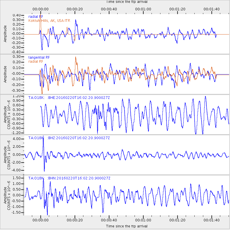
O18K Koktuh Hills, AK, USA - Earthquake Result Viewer
*The percent match for this event was below the threshold and hence no stack was calculated.
| Earthquake location: |
Fiji Islands Region |
| Earthquake latitude/longitude: |
-21.9/-179.4 |
| Earthquake time(UTC): |
2016/02/20 (051) 15:51:22 GMT |
| Earthquake Depth: |
579 km |
| Earthquake Magnitude: |
5.8 MB |
| Earthquake Catalog/Contributor: |
NEIC PDE/NEIC COMCAT |
|
| Network: |
TA USArray Transportable Network (new EarthScope stations) |
| Station: |
O18K Koktuh Hills, AK, USA |
| Lat/Lon: |
59.85 N/155.21 W |
| Elevation: |
544 m |
|
| Distance: |
83.8 deg |
| Az: |
11.988 deg |
| Baz: |
202.466 deg |
| Ray Param: |
$rayparam |
*The percent match for this event was below the threshold and hence was not used in the summary stack. |
|
| Radial Match: |
58.869354 % |
| Radial Bump: |
400 |
| Transverse Match: |
47.35295 % |
| Transverse Bump: |
400 |
| SOD ConfigId: |
7422571 |
| Insert Time: |
2019-04-21 22:59:13.262 +0000 |
| GWidth: |
2.5 |
| Max Bumps: |
400 |
| Tol: |
0.001 |
|
Signal To Noise
| Channel | StoN | STA | LTA |
| TA:O18K: :BHZ:20160220T16:02:20.900027Z | 3.5588944 | 1.6287826E-6 | 4.5766532E-7 |
| TA:O18K: :BHN:20160220T16:02:20.900027Z | 0.94182724 | 7.0697905E-7 | 7.506462E-7 |
| TA:O18K: :BHE:20160220T16:02:20.900027Z | 1.1437244 | 4.6966932E-7 | 4.1064902E-7 |
| Arrivals |
| Ps | |
| PpPs | |
| PsPs/PpSs | |


