You are here: Home > Network List > AZ - ANZA Regional Network Stations List
> Station SMER AZ.SMER > Earthquake Result Viewer
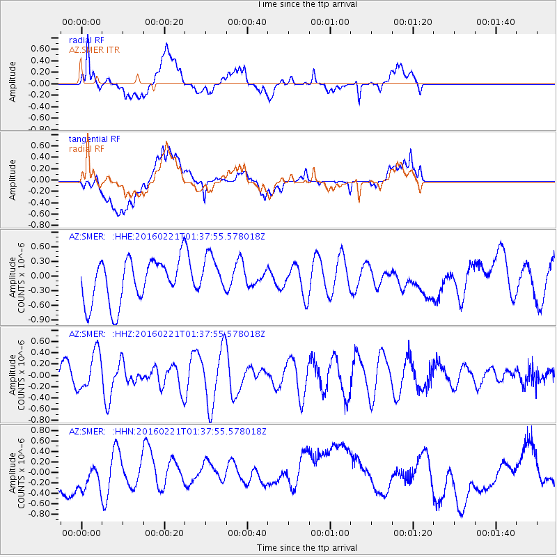
SMER AZ.SMER - Earthquake Result Viewer
*The percent match for this event was below the threshold and hence no stack was calculated.
| Earthquake location: |
Central Mid-Atlantic Ridge |
| Earthquake latitude/longitude: |
4.7/-32.6 |
| Earthquake time(UTC): |
2016/02/21 (052) 01:26:02 GMT |
| Earthquake Depth: |
10 km |
| Earthquake Magnitude: |
5.3 mb |
| Earthquake Catalog/Contributor: |
NEIC PDE/us |
|
| Network: |
AZ ANZA Regional Network |
| Station: |
SMER AZ.SMER |
| Lat/Lon: |
33.46 N/117.17 W |
| Elevation: |
355 m |
|
| Distance: |
82.9 deg |
| Az: |
302.999 deg |
| Baz: |
89.053 deg |
| Ray Param: |
$rayparam |
*The percent match for this event was below the threshold and hence was not used in the summary stack. |
|
| Radial Match: |
36.82282 % |
| Radial Bump: |
400 |
| Transverse Match: |
32.431038 % |
| Transverse Bump: |
400 |
| SOD ConfigId: |
7422571 |
| Insert Time: |
2019-04-21 23:02:23.637 +0000 |
| GWidth: |
2.5 |
| Max Bumps: |
400 |
| Tol: |
0.001 |
|
Signal To Noise
| Channel | StoN | STA | LTA |
| AZ:SMER: :HHZ:20160221T01:37:55.578018Z | 1.884872 | 3.4899557E-7 | 1.8515611E-7 |
| AZ:SMER: :HHN:20160221T01:37:55.578018Z | 0.62867516 | 3.2059123E-7 | 5.099473E-7 |
| AZ:SMER: :HHE:20160221T01:37:55.578018Z | 0.9025613 | 4.054523E-7 | 4.4922416E-7 |
| Arrivals |
| Ps | |
| PpPs | |
| PsPs/PpSs | |


