You are here: Home > Network List > CI - Caltech Regional Seismic Network Stations List
> Station MPP McPhearson Peak > Earthquake Result Viewer
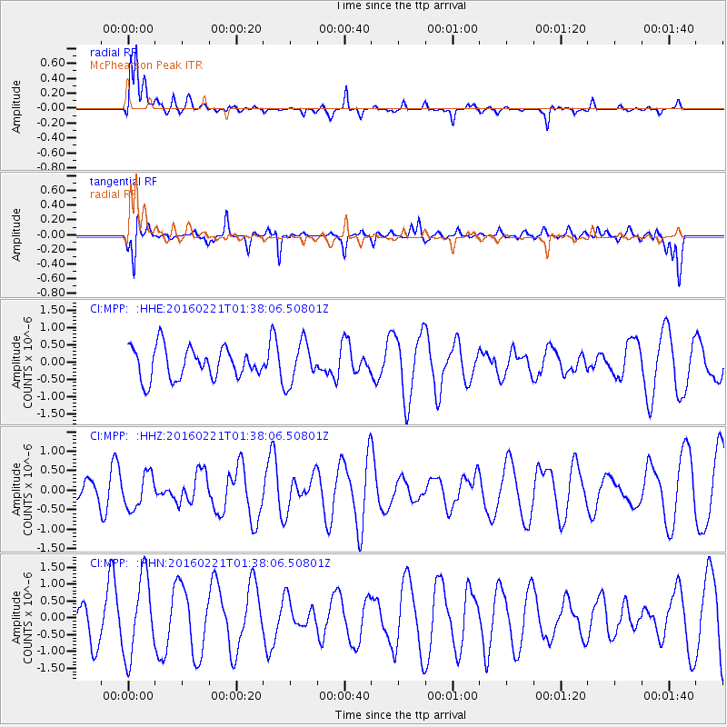
MPP McPhearson Peak - Earthquake Result Viewer
*The percent match for this event was below the threshold and hence no stack was calculated.
| Earthquake location: |
Central Mid-Atlantic Ridge |
| Earthquake latitude/longitude: |
4.7/-32.6 |
| Earthquake time(UTC): |
2016/02/21 (052) 01:26:02 GMT |
| Earthquake Depth: |
10 km |
| Earthquake Magnitude: |
5.3 mb |
| Earthquake Catalog/Contributor: |
NEIC PDE/us |
|
| Network: |
CI Caltech Regional Seismic Network |
| Station: |
MPP McPhearson Peak |
| Lat/Lon: |
34.89 N/119.81 W |
| Elevation: |
1739 m |
|
| Distance: |
85.0 deg |
| Az: |
304.495 deg |
| Baz: |
87.733 deg |
| Ray Param: |
$rayparam |
*The percent match for this event was below the threshold and hence was not used in the summary stack. |
|
| Radial Match: |
68.87723 % |
| Radial Bump: |
373 |
| Transverse Match: |
64.19851 % |
| Transverse Bump: |
309 |
| SOD ConfigId: |
7422571 |
| Insert Time: |
2019-04-21 23:03:07.197 +0000 |
| GWidth: |
2.5 |
| Max Bumps: |
400 |
| Tol: |
0.001 |
|
Signal To Noise
| Channel | StoN | STA | LTA |
| CI:MPP: :HHZ:20160221T01:38:06.50801Z | 1.487144 | 4.4366604E-7 | 2.9833427E-7 |
| CI:MPP: :HHN:20160221T01:38:06.50801Z | 2.6023521 | 1.186432E-6 | 4.559075E-7 |
| CI:MPP: :HHE:20160221T01:38:06.50801Z | 1.3210635 | 5.8970886E-7 | 4.463895E-7 |
| Arrivals |
| Ps | |
| PpPs | |
| PsPs/PpSs | |


