You are here: Home > Network List > AZ - ANZA Regional Network Stations List
> Station FRD AZ.FRD > Earthquake Result Viewer
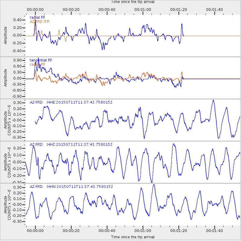
FRD AZ.FRD - Earthquake Result Viewer
*The percent match for this event was below the threshold and hence no stack was calculated.
| Earthquake location: |
East Of Kuril Islands |
| Earthquake latitude/longitude: |
43.9/148.0 |
| Earthquake time(UTC): |
2015/07/11 (192) 11:26:59 GMT |
| Earthquake Depth: |
32 km |
| Earthquake Magnitude: |
5.5 MB |
| Earthquake Catalog/Contributor: |
NEIC PDE/NEIC COMCAT |
|
| Network: |
AZ ANZA Regional Network |
| Station: |
FRD AZ.FRD |
| Lat/Lon: |
33.49 N/116.60 W |
| Elevation: |
1164 m |
|
| Distance: |
71.2 deg |
| Az: |
61.532 deg |
| Baz: |
310.496 deg |
| Ray Param: |
$rayparam |
*The percent match for this event was below the threshold and hence was not used in the summary stack. |
|
| Radial Match: |
66.5592 % |
| Radial Bump: |
400 |
| Transverse Match: |
79.912445 % |
| Transverse Bump: |
400 |
| SOD ConfigId: |
1085051 |
| Insert Time: |
2015-07-25 11:47:28.531 +0000 |
| GWidth: |
2.5 |
| Max Bumps: |
400 |
| Tol: |
0.001 |
|
Signal To Noise
| Channel | StoN | STA | LTA |
| AZ:FRD: :HHZ:20150711T11:37:43.758015Z | 1.1938741 | 1.4060474E-7 | 1.17771826E-7 |
| AZ:FRD: :HHN:20150711T11:37:43.758015Z | 1.0387034 | 1.5971685E-7 | 1.537656E-7 |
| AZ:FRD: :HHE:20150711T11:37:43.758015Z | 0.6658219 | 8.591935E-8 | 1.2904255E-7 |
| Arrivals |
| Ps | |
| PpPs | |
| PsPs/PpSs | |


