You are here: Home > Network List > TA - USArray Transportable Network (new EarthScope stations) Stations List
> Station M53A WI Miller and Sons, Farmdale, OH, USA > Earthquake Result Viewer
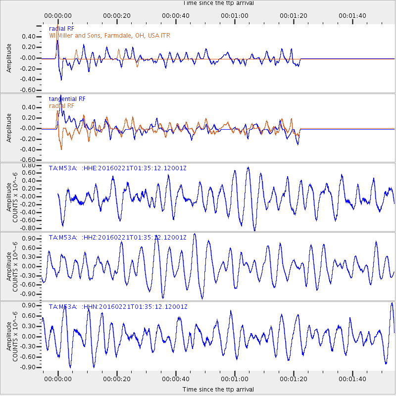
M53A WI Miller and Sons, Farmdale, OH, USA - Earthquake Result Viewer
*The percent match for this event was below the threshold and hence no stack was calculated.
| Earthquake location: |
Central Mid-Atlantic Ridge |
| Earthquake latitude/longitude: |
4.7/-32.6 |
| Earthquake time(UTC): |
2016/02/21 (052) 01:26:02 GMT |
| Earthquake Depth: |
10 km |
| Earthquake Magnitude: |
5.3 mb |
| Earthquake Catalog/Contributor: |
NEIC PDE/us |
|
| Network: |
TA USArray Transportable Network (new EarthScope stations) |
| Station: |
M53A WI Miller and Sons, Farmdale, OH, USA |
| Lat/Lon: |
41.44 N/80.68 W |
| Elevation: |
334 m |
|
| Distance: |
56.3 deg |
| Az: |
317.768 deg |
| Baz: |
117.003 deg |
| Ray Param: |
$rayparam |
*The percent match for this event was below the threshold and hence was not used in the summary stack. |
|
| Radial Match: |
55.965664 % |
| Radial Bump: |
400 |
| Transverse Match: |
65.488686 % |
| Transverse Bump: |
400 |
| SOD ConfigId: |
7422571 |
| Insert Time: |
2019-04-21 23:08:12.045 +0000 |
| GWidth: |
2.5 |
| Max Bumps: |
400 |
| Tol: |
0.001 |
|
Signal To Noise
| Channel | StoN | STA | LTA |
| TA:M53A: :HHZ:20160221T01:35:12.12001Z | 1.000447 | 2.713704E-7 | 2.7124915E-7 |
| TA:M53A: :HHN:20160221T01:35:12.12001Z | 2.2538414 | 5.7275565E-7 | 2.541242E-7 |
| TA:M53A: :HHE:20160221T01:35:12.12001Z | 0.72269034 | 1.7909119E-7 | 2.4781178E-7 |
| Arrivals |
| Ps | |
| PpPs | |
| PsPs/PpSs | |


