You are here: Home > Network List > TA - USArray Transportable Network (new EarthScope stations) Stations List
> Station Z41A Richland Creek Farm, El Dorado, AR, USA > Earthquake Result Viewer
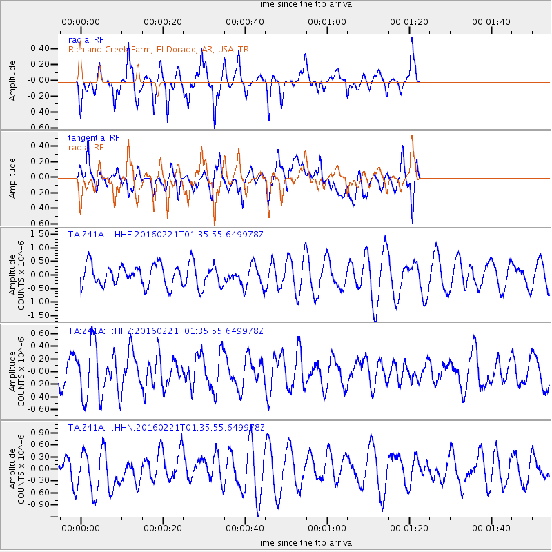
Z41A Richland Creek Farm, El Dorado, AR, USA - Earthquake Result Viewer
*The percent match for this event was below the threshold and hence no stack was calculated.
| Earthquake location: |
Central Mid-Atlantic Ridge |
| Earthquake latitude/longitude: |
4.7/-32.6 |
| Earthquake time(UTC): |
2016/02/21 (052) 01:26:02 GMT |
| Earthquake Depth: |
10 km |
| Earthquake Magnitude: |
5.3 mb |
| Earthquake Catalog/Contributor: |
NEIC PDE/us |
|
| Network: |
TA USArray Transportable Network (new EarthScope stations) |
| Station: |
Z41A Richland Creek Farm, El Dorado, AR, USA |
| Lat/Lon: |
33.26 N/92.80 W |
| Elevation: |
62 m |
|
| Distance: |
62.6 deg |
| Az: |
305.049 deg |
| Baz: |
103.149 deg |
| Ray Param: |
$rayparam |
*The percent match for this event was below the threshold and hence was not used in the summary stack. |
|
| Radial Match: |
54.715553 % |
| Radial Bump: |
272 |
| Transverse Match: |
48.698277 % |
| Transverse Bump: |
400 |
| SOD ConfigId: |
7422571 |
| Insert Time: |
2019-04-21 23:08:22.470 +0000 |
| GWidth: |
2.5 |
| Max Bumps: |
400 |
| Tol: |
0.001 |
|
Signal To Noise
| Channel | StoN | STA | LTA |
| TA:Z41A: :HHZ:20160221T01:35:55.649978Z | 1.8691902 | 4.3609592E-7 | 2.333074E-7 |
| TA:Z41A: :HHN:20160221T01:35:55.649978Z | 1.1603866 | 4.979999E-7 | 4.2916724E-7 |
| TA:Z41A: :HHE:20160221T01:35:55.649978Z | 1.071182 | 4.0925244E-7 | 3.8205687E-7 |
| Arrivals |
| Ps | |
| PpPs | |
| PsPs/PpSs | |


