You are here: Home > Network List > CN - Canadian National Seismograph Network Stations List
> Station INK INUVIK, NT > Earthquake Result Viewer
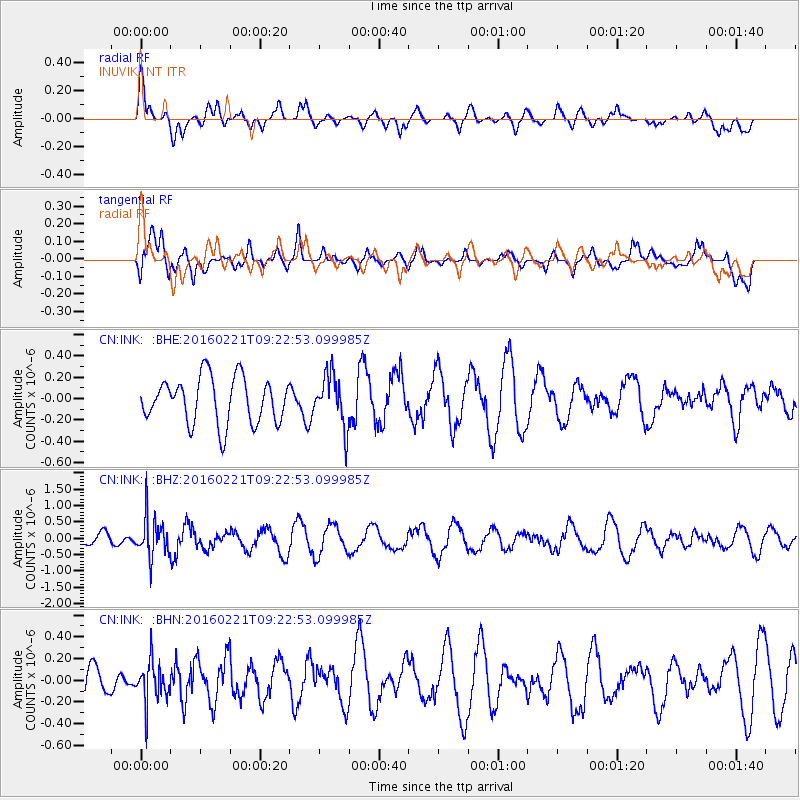
INK INUVIK, NT - Earthquake Result Viewer
*The percent match for this event was below the threshold and hence no stack was calculated.
| Earthquake location: |
Hindu Kush Region, Afghanistan |
| Earthquake latitude/longitude: |
36.5/70.9 |
| Earthquake time(UTC): |
2016/02/21 (052) 09:12:08 GMT |
| Earthquake Depth: |
177 km |
| Earthquake Magnitude: |
5.5 MB |
| Earthquake Catalog/Contributor: |
NEIC PDE/NEIC COMCAT |
|
| Network: |
CN Canadian National Seismograph Network |
| Station: |
INK INUVIK, NT |
| Lat/Lon: |
68.31 N/133.53 W |
| Elevation: |
44 m |
|
| Distance: |
73.9 deg |
| Az: |
9.191 deg |
| Baz: |
339.74 deg |
| Ray Param: |
$rayparam |
*The percent match for this event was below the threshold and hence was not used in the summary stack. |
|
| Radial Match: |
62.144047 % |
| Radial Bump: |
400 |
| Transverse Match: |
60.987595 % |
| Transverse Bump: |
400 |
| SOD ConfigId: |
7422571 |
| Insert Time: |
2019-04-21 23:12:07.796 +0000 |
| GWidth: |
2.5 |
| Max Bumps: |
400 |
| Tol: |
0.001 |
|
Signal To Noise
| Channel | StoN | STA | LTA |
| CN:INK: :BHZ:20160221T09:22:53.099985Z | 3.3790336 | 5.9327505E-7 | 1.7557537E-7 |
| CN:INK: :BHN:20160221T09:22:53.099985Z | 1.1983052 | 1.8675607E-7 | 1.5585016E-7 |
| CN:INK: :BHE:20160221T09:22:53.099985Z | 1.1087341 | 2.3692895E-7 | 2.1369321E-7 |
| Arrivals |
| Ps | |
| PpPs | |
| PsPs/PpSs | |


