You are here: Home > Network List > UW - Pacific Northwest Regional Seismic Network Stations List
> Station HOOD Mt Hood Meadows, OR CREST BB SMO > Earthquake Result Viewer
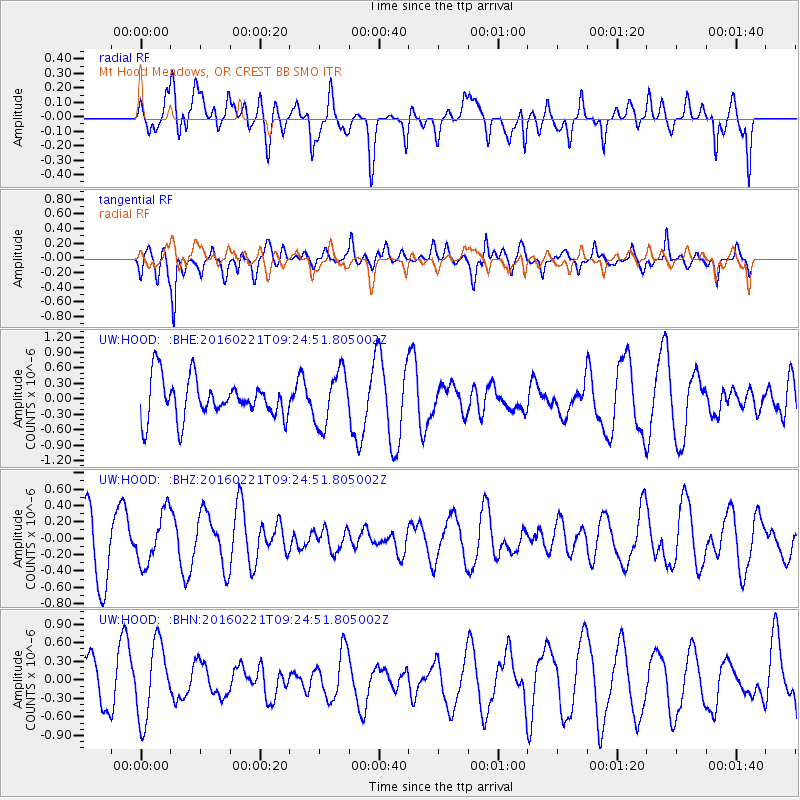
HOOD Mt Hood Meadows, OR CREST BB SMO - Earthquake Result Viewer
*The percent match for this event was below the threshold and hence no stack was calculated.
| Earthquake location: |
Hindu Kush Region, Afghanistan |
| Earthquake latitude/longitude: |
36.5/70.9 |
| Earthquake time(UTC): |
2016/02/21 (052) 09:12:08 GMT |
| Earthquake Depth: |
177 km |
| Earthquake Magnitude: |
5.5 MB |
| Earthquake Catalog/Contributor: |
NEIC PDE/NEIC COMCAT |
|
| Network: |
UW Pacific Northwest Regional Seismic Network |
| Station: |
HOOD Mt Hood Meadows, OR CREST BB SMO |
| Lat/Lon: |
45.32 N/121.65 W |
| Elevation: |
1520 m |
|
| Distance: |
97.8 deg |
| Az: |
8.876 deg |
| Baz: |
349.848 deg |
| Ray Param: |
$rayparam |
*The percent match for this event was below the threshold and hence was not used in the summary stack. |
|
| Radial Match: |
65.27134 % |
| Radial Bump: |
400 |
| Transverse Match: |
51.106422 % |
| Transverse Bump: |
400 |
| SOD ConfigId: |
7422571 |
| Insert Time: |
2019-04-21 23:14:28.855 +0000 |
| GWidth: |
2.5 |
| Max Bumps: |
400 |
| Tol: |
0.001 |
|
Signal To Noise
| Channel | StoN | STA | LTA |
| UW:HOOD: :BHZ:20160221T09:24:51.805002Z | 0.96178854 | 3.1144364E-7 | 3.2381718E-7 |
| UW:HOOD: :BHN:20160221T09:24:51.805002Z | 1.8400599 | 6.1692253E-7 | 3.3527306E-7 |
| UW:HOOD: :BHE:20160221T09:24:51.805002Z | 1.3651257 | 5.2621033E-7 | 3.854666E-7 |
| Arrivals |
| Ps | |
| PpPs | |
| PsPs/PpSs | |


