You are here: Home > Network List > IC - New China Digital Seismograph Network Stations List
> Station WMQ Urumqi, Xinjiang Province, China > Earthquake Result Viewer
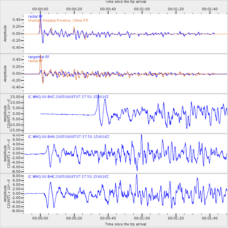
WMQ Urumqi, Xinjiang Province, China - Earthquake Result Viewer

| Earthquake location: |
New Ireland Region, P.N.G. |
| Earthquake latitude/longitude: |
-4.5/153.5 |
| Earthquake time(UTC): |
2005/09/09 (252) 07:26:43 GMT |
| Earthquake Depth: |
90 km |
| Earthquake Magnitude: |
6.3 MB, 7.7 MW, 7.5 MW |
| Earthquake Catalog/Contributor: |
WHDF/NEIC |
|
| Network: |
IC New China Digital Seismograph Network |
| Station: |
WMQ Urumqi, Xinjiang Province, China |
| Lat/Lon: |
43.82 N/87.69 E |
| Elevation: |
903 m |
|
| Distance: |
76.0 deg |
| Az: |
317.134 deg |
| Baz: |
110.455 deg |
| Ray Param: |
0.051079392 |
| Estimated Moho Depth: |
45.75 km |
| Estimated Crust Vp/Vs: |
1.82 |
| Assumed Crust Vp: |
6.242 km/s |
| Estimated Crust Vs: |
3.425 km/s |
| Estimated Crust Poisson's Ratio: |
0.28 |
|
| Radial Match: |
95.090805 % |
| Radial Bump: |
400 |
| Transverse Match: |
84.970856 % |
| Transverse Bump: |
400 |
| SOD ConfigId: |
2475 |
| Insert Time: |
2010-03-05 00:10:09.880 +0000 |
| GWidth: |
2.5 |
| Max Bumps: |
400 |
| Tol: |
0.001 |
|
Signal To Noise
| Channel | StoN | STA | LTA |
| IC:WMQ:00:BHN:20050909T07:37:50.159016Z | 9.603392 | 1.3125091E-6 | 1.3667142E-7 |
| IC:WMQ:00:BHE:20050909T07:37:50.159016Z | 18.383656 | 2.3612859E-6 | 1.2844485E-7 |
| IC:WMQ:00:BHZ:20050909T07:37:50.159016Z | 26.617586 | 6.375013E-6 | 2.395038E-7 |
| Arrivals |
| Ps | 6.2 SECOND |
| PpPs | 20 SECOND |
| PsPs/PpSs | 26 SECOND |


