You are here: Home > Network List > CN - Canadian National Seismograph Network Stations List
> Station INK INUVIK, NT > Earthquake Result Viewer
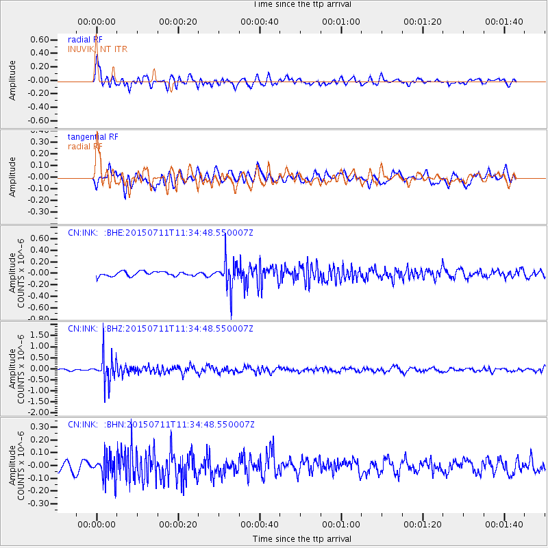
INK INUVIK, NT - Earthquake Result Viewer
*The percent match for this event was below the threshold and hence no stack was calculated.
| Earthquake location: |
East Of Kuril Islands |
| Earthquake latitude/longitude: |
43.9/148.0 |
| Earthquake time(UTC): |
2015/07/11 (192) 11:26:59 GMT |
| Earthquake Depth: |
32 km |
| Earthquake Magnitude: |
5.5 MB |
| Earthquake Catalog/Contributor: |
NEIC PDE/NEIC COMCAT |
|
| Network: |
CN Canadian National Seismograph Network |
| Station: |
INK INUVIK, NT |
| Lat/Lon: |
68.31 N/133.53 W |
| Elevation: |
44 m |
|
| Distance: |
46.0 deg |
| Az: |
30.451 deg |
| Baz: |
279.816 deg |
| Ray Param: |
$rayparam |
*The percent match for this event was below the threshold and hence was not used in the summary stack. |
|
| Radial Match: |
60.01702 % |
| Radial Bump: |
400 |
| Transverse Match: |
54.597195 % |
| Transverse Bump: |
400 |
| SOD ConfigId: |
1085051 |
| Insert Time: |
2015-07-25 11:56:46.846 +0000 |
| GWidth: |
2.5 |
| Max Bumps: |
400 |
| Tol: |
0.001 |
|
Signal To Noise
| Channel | StoN | STA | LTA |
| CN:INK: :BHZ:20150711T11:34:48.550007Z | 10.9484215 | 5.9683634E-7 | 5.451346E-8 |
| CN:INK: :BHN:20150711T11:34:48.550007Z | 2.2065296 | 9.4632334E-8 | 4.2887407E-8 |
| CN:INK: :BHE:20150711T11:34:48.550007Z | 6.1216297 | 2.3718849E-7 | 3.8745974E-8 |
| Arrivals |
| Ps | |
| PpPs | |
| PsPs/PpSs | |


