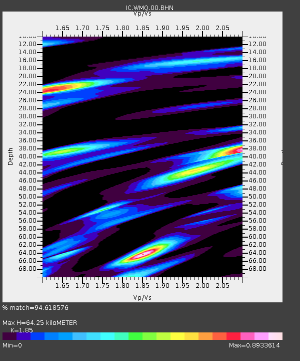
WMQ Urumqi, Xinjiang Province, China - Earthquake Result Viewer

Earthquake location: Northern Sumatra, Indonesia
Earthquake latitude/longitude: 1.6/99.1
Earthquake time(UTC): 2008/05/19 (140) 14:26:45 GMT
Earthquake Depth: 10 km
Earthquake Magnitude: 5.8 MB, 6.0 MS, 6.0 MW, 6.0 MW
Earthquake Catalog/Contributor: WHDF/NEIC
Network: IC New China Digital Seismograph Network
Station: WMQ Urumqi, Xinjiang Province, China
Lat/Lon: 43.82 N/87.69 E
Elevation: 903 m
Distance: 43.2 deg
Az: 347.886 deg
Baz: 163.153 deg
Ray Param: 0.07269328
Estimated Moho Depth: 64.25 km
Estimated Crust Vp/Vs: 1.85
Assumed Crust Vp: 6.242 km/s
Estimated Crust Vs: 3.374 km/s
Estimated Crust Poisson's Ratio: 0.29
Radial Match: 94.618576 %
Radial Bump: 376
Transverse Match: 85.04282 %
Transverse Bump: 400
SOD ConfigId: 2504
Insert Time: 2010-03-05 00:10:43.000 +0000
GWidth: 2.5
Max Bumps: 400
Tol: 0.001

Signal To Noise

ChannelStoNSTALTA
IC:WMQ:00:BHN:20080519T14:34:15.250988Z7.26177264.1169483E-75.6693434E-8
IC:WMQ:00:BHE:20080519T14:34:15.250988Z4.36236672.3573318E-75.4037912E-8
IC:WMQ:00:BHZ:20080519T14:34:15.250988Z3.0615991.3064572E-74.267238E-8
Arrivals
Ps9.3 SECOND
PpPs28 SECOND
PsPs/PpSs37 SECOND