You are here: Home > Network List > CN - Canadian National Seismograph Network Stations List
> Station VIB VAN INLET, BC > Earthquake Result Viewer
VIB VAN INLET, BC - Earthquake Result Viewer
| Earthquake location: |
East Of Kuril Islands |
| Earthquake latitude/longitude: |
43.9/148.0 |
| Earthquake time(UTC): |
2015/07/11 (192) 11:26:59 GMT |
| Earthquake Depth: |
32 km |
| Earthquake Magnitude: |
5.5 MB |
| Earthquake Catalog/Contributor: |
NEIC PDE/NEIC COMCAT |
|
| Network: |
CN Canadian National Seismograph Network |
| Station: |
VIB VAN INLET, BC |
| Lat/Lon: |
53.25 N/132.54 W |
| Elevation: |
1008 m |
|
| Distance: |
50.8 deg |
| Az: |
49.658 deg |
| Baz: |
293.518 deg |
| Ray Param: |
0.067753114 |
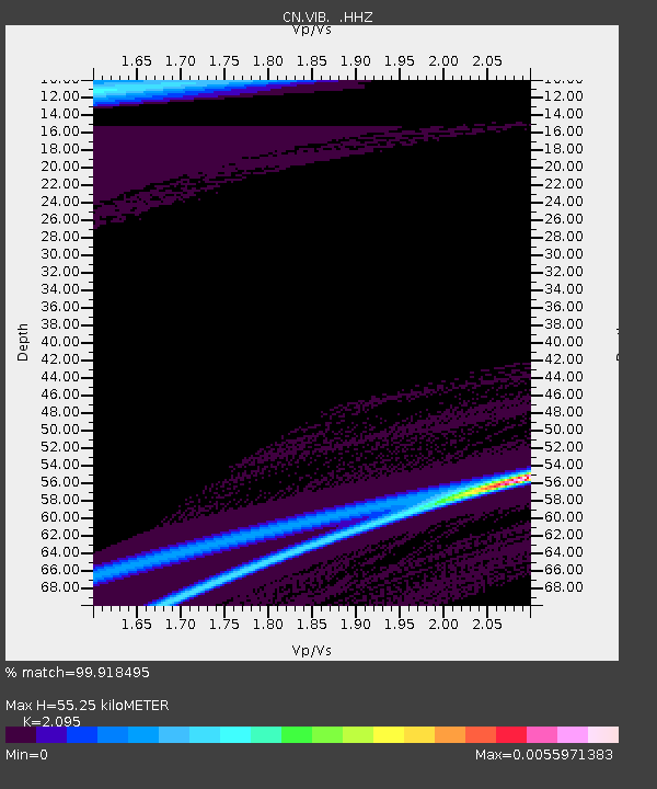
| Estimated Moho Depth: |
55.25 km |
| Estimated Crust Vp/Vs: |
2.10 |
| Assumed Crust Vp: |
6.183 km/s |
| Estimated Crust Vs: |
2.951 km/s |
| Estimated Crust Poisson's Ratio: |
0.35 |
|
| Radial Match: |
99.918495 % |
| Radial Bump: |
15 |
| Transverse Match: |
99.99108 % |
| Transverse Bump: |
3 |
| SOD ConfigId: |
1085051 |
| Insert Time: |
2015-07-25 11:57:28.930 +0000 |
| GWidth: |
2.5 |
| Max Bumps: |
400 |
| Tol: |
0.001 |
|
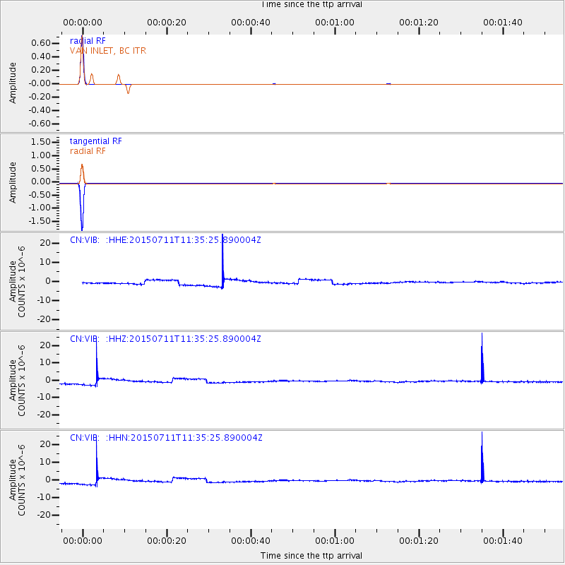
Signal To Noise
| Channel | StoN | STA | LTA |
| CN:VIB: :HHZ:20150711T11:35:25.890004Z | 3.8777041 | 3.6790236E-6 | 9.4876333E-7 |
| CN:VIB: :HHN:20150711T11:35:25.890004Z | 3.9291954 | 3.6541783E-6 | 9.300067E-7 |
| CN:VIB: :HHE:20150711T11:35:25.890004Z | 3.9262786 | 3.677922E-6 | 9.367451E-7 |
| Arrivals |
| Ps | 10 SECOND |
| PpPs | 26 SECOND |
| PsPs/PpSs | 37 SECOND |


