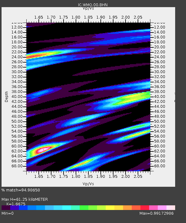
WMQ Urumqi, Xinjiang Province, China - Earthquake Result Viewer
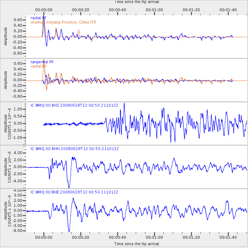
Earthquake location: Andaman Islands, India Region
Earthquake latitude/longitude: 10.8/91.7
Earthquake time(UTC): 2008/06/28 (180) 12:54:46 GMT
Earthquake Depth: 15 km
Earthquake Magnitude: 5.9 MB, 6.0 MS, 6.1 MW, 6.1 MW
Earthquake Catalog/Contributor: WHDF/NEIC
Network: IC New China Digital Seismograph Network
Station: WMQ Urumqi, Xinjiang Province, China
Lat/Lon: 43.82 N/87.69 E
Elevation: 903 m
Distance: 33.0 deg
Az: 354.663 deg
Baz: 172.748 deg
Ray Param: 0.07838241
Estimated Moho Depth: 61.25 km
Estimated Crust Vp/Vs: 1.67
Assumed Crust Vp: 6.242 km/s
Estimated Crust Vs: 3.743 km/s
Estimated Crust Poisson's Ratio: 0.22
Radial Match: 94.98658 %
Radial Bump: 388
Transverse Match: 80.94298 %
Transverse Bump: 400
SOD ConfigId: 2504
Insert Time: 2010-03-05 00:11:05.443 +0000
GWidth: 2.5
Max Bumps: 400
Tol: 0.001

Signal To Noise

ChannelStoNSTALTA
IC:WMQ:00:BHN:20080628T13:00:50.211013Z21.64431.1148486E-65.1507723E-8
IC:WMQ:00:BHE:20080628T13:00:50.211013Z13.1876376.364788E-74.826329E-8
IC:WMQ:00:BHZ:20080628T13:00:50.211013Z5.08617352.0959759E-74.1209287E-8
Arrivals
Ps7.1 SECOND
PpPs24 SECOND
PsPs/PpSs31 SECOND