You are here: Home > Network List > YT07 - POLENET Stations List
> Station THUR THUR > Earthquake Result Viewer
THUR THUR - Earthquake Result Viewer
| Earthquake location: |
South Of Australia |
| Earthquake latitude/longitude: |
-63.1/144.8 |
| Earthquake time(UTC): |
2016/02/23 (054) 18:08:46 GMT |
| Earthquake Depth: |
7.7 km |
| Earthquake Magnitude: |
5.9 MB |
| Earthquake Catalog/Contributor: |
NEIC PDE/NEIC COMCAT |
|
| Network: |
YT POLENET |
| Station: |
THUR THUR |
| Lat/Lon: |
72.53 S/97.56 W |
| Elevation: |
239 m |
|
| Distance: |
38.2 deg |
| Az: |
154.384 deg |
| Baz: |
220.576 deg |
| Ray Param: |
0.07568568 |
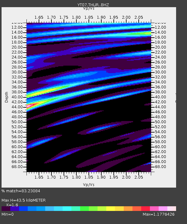
| Estimated Moho Depth: |
43.5 km |
| Estimated Crust Vp/Vs: |
1.60 |
| Assumed Crust Vp: |
6.43 km/s |
| Estimated Crust Vs: |
4.019 km/s |
| Estimated Crust Poisson's Ratio: |
0.18 |
|
| Radial Match: |
83.23084 % |
| Radial Bump: |
400 |
| Transverse Match: |
52.547676 % |
| Transverse Bump: |
400 |
| SOD ConfigId: |
7422571 |
| Insert Time: |
2019-04-21 23:30:23.139 +0000 |
| GWidth: |
2.5 |
| Max Bumps: |
400 |
| Tol: |
0.001 |
|

Signal To Noise
| Channel | StoN | STA | LTA |
| YT:THUR: :BHZ:20160223T18:15:36.14999Z | 3.3184884 | 9.128788E-7 | 2.7508875E-7 |
| YT:THUR: :BHN:20160223T18:15:36.14999Z | 2.456658 | 5.7988035E-7 | 2.360444E-7 |
| YT:THUR: :BHE:20160223T18:15:36.14999Z | 1.2842803 | 4.325688E-7 | 3.3681806E-7 |
| Arrivals |
| Ps | 4.4 SECOND |
| PpPs | 16 SECOND |
| PsPs/PpSs | 21 SECOND |


