You are here: Home > Network List > IC - New China Digital Seismograph Network Stations List
> Station WMQ Urumqi, Xinjiang Province, China > Earthquake Result Viewer
WMQ Urumqi, Xinjiang Province, China - Earthquake Result Viewer
| Earthquake location: |
Eastern New Guinea Reg., P.N.G. |
| Earthquake latitude/longitude: |
-6.1/147.3 |
| Earthquake time(UTC): |
2008/08/30 (243) 06:54:07 GMT |
| Earthquake Depth: |
75 km |
| Earthquake Magnitude: |
6.1 MB, 6.4 MW, 6.3 MW |
| Earthquake Catalog/Contributor: |
WHDF/NEIC |
|
| Network: |
IC New China Digital Seismograph Network |
| Station: |
WMQ Urumqi, Xinjiang Province, China |
| Lat/Lon: |
43.82 N/87.69 E |
| Elevation: |
903 m |
|
| Distance: |
73.1 deg |
| Az: |
319.281 deg |
| Baz: |
116.345 deg |
| Ray Param: |
0.05308161 |
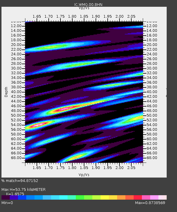
| Estimated Moho Depth: |
53.75 km |
| Estimated Crust Vp/Vs: |
1.66 |
| Assumed Crust Vp: |
6.242 km/s |
| Estimated Crust Vs: |
3.766 km/s |
| Estimated Crust Poisson's Ratio: |
0.21 |
|
| Radial Match: |
94.87152 % |
| Radial Bump: |
390 |
| Transverse Match: |
88.75461 % |
| Transverse Bump: |
400 |
| SOD ConfigId: |
2504 |
| Insert Time: |
2010-03-05 00:11:42.274 +0000 |
| GWidth: |
2.5 |
| Max Bumps: |
400 |
| Tol: |
0.001 |
|
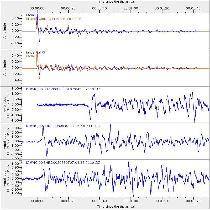
Signal To Noise
| Channel | StoN | STA | LTA |
| IC:WMQ:00:BHN:20080830T07:04:58.711013Z | 17.79775 | 1.3322624E-6 | 7.485566E-8 |
| IC:WMQ:00:BHE:20080830T07:04:58.711013Z | 4.497195 | 3.072044E-7 | 6.831023E-8 |
| IC:WMQ:00:BHZ:20080830T07:04:58.711013Z | 13.457692 | 5.087042E-7 | 3.780026E-8 |
| Arrivals |
| Ps | 5.9 SECOND |
| PpPs | 22 SECOND |
| PsPs/PpSs | 28 SECOND |


