You are here: Home > Network List > IC - New China Digital Seismograph Network Stations List
> Station WMQ Urumqi, Xinjiang Province, China > Earthquake Result Viewer
WMQ Urumqi, Xinjiang Province, China - Earthquake Result Viewer
| Earthquake location: |
Halmahera, Indonesia |
| Earthquake latitude/longitude: |
1.9/127.4 |
| Earthquake time(UTC): |
2008/09/11 (255) 00:00:02 GMT |
| Earthquake Depth: |
96 km |
| Earthquake Magnitude: |
6.2 MB, 6.6 MW, 6.6 MW |
| Earthquake Catalog/Contributor: |
WHDF/NEIC |
|
| Network: |
IC New China Digital Seismograph Network |
| Station: |
WMQ Urumqi, Xinjiang Province, China |
| Lat/Lon: |
43.82 N/87.69 E |
| Elevation: |
903 m |
|
| Distance: |
54.6 deg |
| Az: |
325.465 deg |
| Baz: |
128.484 deg |
| Ray Param: |
0.065059796 |
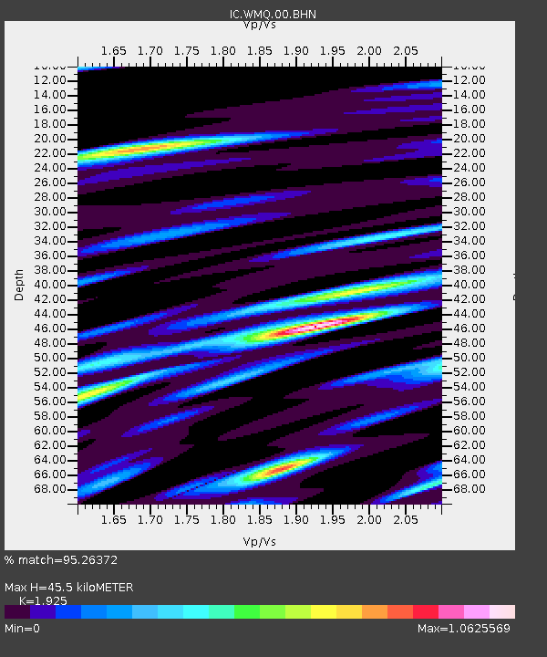
| Estimated Moho Depth: |
45.5 km |
| Estimated Crust Vp/Vs: |
1.92 |
| Assumed Crust Vp: |
6.242 km/s |
| Estimated Crust Vs: |
3.243 km/s |
| Estimated Crust Poisson's Ratio: |
0.32 |
|
| Radial Match: |
95.26372 % |
| Radial Bump: |
400 |
| Transverse Match: |
88.82496 % |
| Transverse Bump: |
400 |
| SOD ConfigId: |
2560 |
| Insert Time: |
2010-03-05 00:11:49.406 +0000 |
| GWidth: |
2.5 |
| Max Bumps: |
400 |
| Tol: |
0.001 |
|
Signal To Noise
| Channel | StoN | STA | LTA |
| IC:WMQ:00:BHN:20080911T00:08:50.509998Z | 69.50359 | 4.5183765E-6 | 6.5009246E-8 |
| IC:WMQ:00:BHE:20080911T00:08:50.509998Z | 30.603912 | 1.768108E-6 | 5.777392E-8 |
| IC:WMQ:00:BHZ:20080911T00:08:50.509998Z | 31.732807 | 1.799559E-6 | 5.670973E-8 |
| Arrivals |
| Ps | 7.1 SECOND |
| PpPs | 20 SECOND |
| PsPs/PpSs | 27 SECOND |


